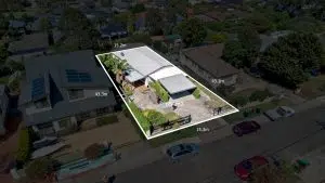
Land Surveying Costing Guide Australia 2023
At Avian Australia, our primary focus is to provide the highest level of customer service and unmatched quality in the fields of inspection, surveying, 3D laser scanning, imaging and photogrammetry. It’s our focus to provide architects, engineers, and construction clients with data-driven insights about their projects to allow them to


22 Benefits of 3D laser scanning in Architecture and Construction
3D Laser scanning is among the most popular and effective methods to capture accurate site data. It offers architects and designers plenty of benefits over conventional surveying methods. Read on to know about the advantages of 3D laser scanning services and how it helps with effective 3D architectural visualisation. Table
How much does 3D laser scanning cost in Australia?
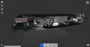
Cutting-edge 3D laser scanning technology has revolutionised the Architecture, Engineering and Construction (AEC) industries across the world, including Australia. Architects, engineers and construction managers can incorporate accurate 3D models into their design and build workflows easily thanks to these lightweight, accurate and portable technologies. With so many advantages and features
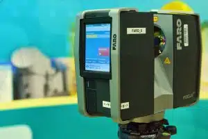
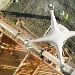
Avian’s 3D Laser Scanning & Surveying Equipment List [Updated 2022]
Introduction For architects, LiDAR scanning, also known as 3D laser scanning, is an absolute table-turner as it can drastically help in re-imagining the interiors, model structures, and building setups that can be digitally visualised with 2D and 3D laser scanning equipment. In the AEC (Architecture, Engineering & Construction) Industry, typically

5 Easily Overlooked 3D Laser Scanning Mistakes & How To Avoid Them
Imagine a scenario where all the equipment is ready, you have set up the total station and made observations and the 3D laser scanner is also set up and ready to scan the site. Just before you carry out the inspection, you find that the LiDAR scanner is not working correctly. Time

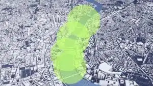
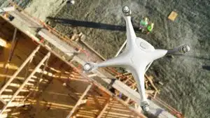
Comprehensive Guide to Corridor Mapping with Commercial Drones
In the dynamic realms of engineering, project management, and urban planning, the demand for precise and efficient corridor mapping is an ever-present challenge. Enter drones – the transformative force reshaping our approach to topographical modelling and understanding the immediate environment in the rapidly evolving world of modern technology. Among the
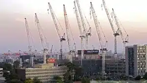
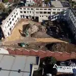
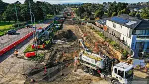
Enhancing Construction site assessment & monitoring with technology in 2023
In the ever-evolving landscape of construction and surveying, technology has brought about transformative changes. The integration of advancements such as GPS, microprocessors, drones, laser scanning, and the Internet of Things (IoT) has significantly streamlined operations for project managers, builders, surveyors, and engineers within the Architecture, Engineering, and Construction (AEC) sectors.
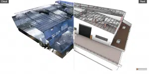
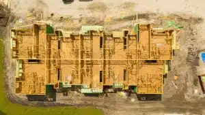
Unlocking Efficiency in Engineering and Construction: The Role of Reality Capture in Project Management
In the world of engineering and construction, where accuracy and efficiency are paramount, embracing innovative technologies is crucial for success. One such technology that has revolutionised the industry is reality capture. Reality capture refers to the process of capturing and creating precise digital representations of physical objects, environments, buildings and
Construction timelapse Costing Guide 2023 + Key Recommendations
Construction time lapse videos help AEC professionals summarise key events during the project and summarise a passage of time in a short period. Time lapse videos make for great communications and marketing material to inform stakeholders, the public and potential clients. Over the years, time lapse videos have become increasingly
Comprehensive Guide to Corridor Mapping with Commercial Drones
In the dynamic realms of engineering, project management, and urban planning, the demand for precise and efficient corridor mapping is an ever-present challenge. Enter drones – the transformative force reshaping our approach to topographical modelling and understanding the immediate environment in the rapidly evolving world of modern technology. Among the

Construction Site Assessment & Monitoring Costing Guide 2023
Technology has changed the way we manage construction and surveying in drastic ways. With the improvements in GPS, microprocessors, drones, laser scanning and internet of things (IoT) we could assume life has been made easier for project managers, builders, surveyors and engineers in the AEC sectors. One area of construction
Site Measure Up – What are the benefits, and why do it?
A construction project is more than just pouring concrete and hammering nails. It involves meticulous planning, coordination and execution. For the pre-construction stage, Architects use land surveys to gather important data about the property to prepare their designs and planning approvals. These surveys give architects insights into the subject property’s
Aerial Asset Inspection Costing Guide [Updated 2023]
Aerial asset inspections have completely changed the way we conduct assessments of difficult to reach positions, over water, at heights or underground. The days when engineers had to setup rope access or seek numerous approvals just to get a condition assessment are long gone. Also, the manual methods of hanging

3D Modelling & 2D Architectural Rendering Cost Guide in Melbourne [2023]
3D Modelling and 2D Architectural Rendering allows you to bring concepts and designs to life via immersive and interactive 2D and 3D environments and replicate buildings into impressive visualisations. This process of generating 3D models when done right, can turn the most complex infrastructure designs into a powerful and feature