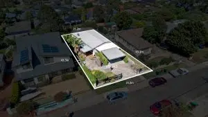
Land Surveying Costing Guide Australia 2025
At Avian Australia, our primary focus is to provide the highest level of customer service and unmatched quality in the fields of inspection, surveying, 3D laser scanning, imaging and photogrammetry. It’s our focus to provide architects, engineers, and construction clients with data-driven insights about their projects to allow them to


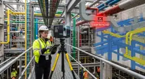
Clash Detection with 3D Laser Scanning
On a complex construction project, the difference between a smooth build and a costly variation often comes down to whether MEP services, structural elements, or architectural components occupy the same space in a 3D BIM or scan-to-BIM model before they conflict on site. That’s exactly what the clash detection process
Floor Plans from 3D Laser Scanning: Process, Accuracy, and Deliverables
Manual measuring has always been the bottleneck in producing accurate floor plans. A tape measure misread by 20mm becomes a structural clash, a costly variation – or worse, a building that doesn’t meet its as-built record. 3D laser scanning floor plans eliminates that risk entirely, replacing guesswork with verified spatial
Key Terminologies in 3D Laser Scanning for AEC
Whether you’re an architect sketching a new high-rise in the Melbourne CBD, an engineer working on a Brisbane tunnel, or a contractor overseeing a heritage façade restoration in Sydney, understanding 3D laser scanning terminology is essential. The AEC (Architecture, Engineering, Construction) industry relies increasingly on digital data capture, turning the

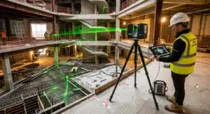
3D Laser Scanning vs. Traditional Surveying for AEC Projects
Accurate site data is crucial to every phase of an Architecture, Engineering and Construction (AEC) project. In Australia, where expansive urban growth in cities like Sydney, Melbourne and Brisbane coexists with heritage preservation and regional infrastructure, precise surveying can make or break project success. Today, a growing number of Australian


Revit Modelling from Point Cloud: Workflow, Tips, and Best Practices
A point cloud is one of the most information-rich datasets you can bring to a construction or renovation project. Millions of verified spatial measurements, captured in hours, reflecting exactly what exists on site. But raw scan data isn’t a usable deliverable on its own. It needs to become a model.

Everything You Need to Know About As-Built Surveys for AEC Projects
Every construction project changes along the way: services get rerouted, structural elements shift, materials are swapped, and dimensions drift from what was drawn. If those changes aren’t captured, the next team to work on the building is designing from drawings that no longer match reality. As-built surveys solve that problem
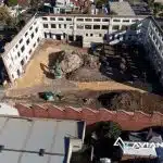
What is a 360 Site Inspection Survey? How it can help with Construction Risk Management?
The Architecture, Construction, and Engineering (AEC ) industries have witnessed a revolutionary shift in site inspection methodologies, evolving from manual, time-consuming processes to the adoption of advanced technological solutions. Among these, 360 Site Inspection Surveys have emerged as a forefront innovation, redefining remote construction site management. Leveraging immersive photography and
Key Terminologies in 3D Laser Scanning for AEC
Whether you’re an architect sketching a new high-rise in the Melbourne CBD, an engineer working on a Brisbane tunnel, or a contractor overseeing a heritage façade restoration in Sydney, understanding 3D laser scanning terminology is essential. The AEC (Architecture, Engineering, Construction) industry relies increasingly on digital data capture, turning the
What is a 360 Site Inspection Survey? How it can help with Construction Risk Management?
The Architecture, Construction, and Engineering (AEC ) industries have witnessed a revolutionary shift in site inspection methodologies, evolving from manual, time-consuming processes to the adoption of advanced technological solutions. Among these, 360 Site Inspection Surveys have emerged as a forefront innovation, redefining remote construction site management. Leveraging immersive photography and

Visual Tree Assessment Techniques for Comprehensive Tree Safety Audits
Trees play an important part in our symbiotic balance with nature, and it is all the more critical now as to how we nurture breathing pockets in our urban landscape. However, this comes with a list of challenges where trees can be hazardous when they break or fall with or
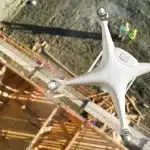
Comprehensive Guide to Corridor Mapping with Commercial Drones
In the dynamic realms of engineering, project management, and urban planning, the demand for precise and efficient corridor mapping is an ever-present challenge. Enter drones – the transformative force reshaping our approach to topographical modelling and understanding the immediate environment in the rapidly evolving world of modern technology. Among the

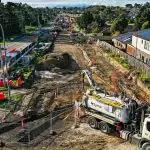
Construction Site Assessment & Monitoring Costing Guide 2023
Technology has changed the way we manage construction and surveying in drastic ways. With the improvements in GPS, microprocessors, drones, laser scanning and internet of things (IoT) we could assume life has been made easier for project managers, builders, surveyors and engineers in the AEC sectors. One area of construction
Visual Tree Assessment Techniques for Comprehensive Tree Safety Audits
Trees play an important part in our symbiotic balance with nature, and it is all the more critical now as to how we nurture breathing pockets in our urban landscape. However, this comes with a list of challenges where trees can be hazardous when they break or fall with or