Services > 3D Laser Scanning > Architects Site Measure Up

The Role of Site Measure Up

Our 3D scanning services play a crucial role in assisting architects, designers, and construction managers. These services eliminate the complexities and time-consuming tasks of manual measurements, streamlining project timelines with accurate data.


Solutions:

  • Updated As-Built Drawings: Our 3D scanning services ensure precise representation of existing conditions.
  • Detailed 3D Models: Use these as a canvas for your architectural designs and renders, ensuring every decision is informed by the site's actual conditions.
  • Precision Digital Twin created as a point cloud provides an archival record of existing conditions to be easily  referenced in future. 
  • Stunning Architectural Visualisations and Renders: Secure client approvals with ease using impressive and realistic  representations.

Outcome: Design structures that are both aesthetically pleasing and based on accurate dimensions, leading to faster project execution and increased client satisfaction.

Designers, while aiming to infuse spaces with creativity, often face challenges due to a lack of comprehensive site details or dimensions, which can hinder the realisation of their creative vision.

Solution: Designers Site Measure Up

  • Detailed 2D and 3D Models: These models act as a canvas, ensuring your design fits perfectly with the site's actual conditions.
  • Comprehensive Site Analysis: Understand every nuance of the site, in all aspects allowing for designs that are both innovative, functional and feasible.
  • Stunning Architectural Visualizations and Renders: Visualise the final outcome, ensuring your designs are bold, functional and beautiful.

Outcome: Create spaces that are not only imaginative but also seamlessly integrate with the existing conditions, leading to designs that truly resonate and work.

Construction managers, aiming for seamless project execution, often face hurdles due to uncertainties in site conditions, leading to costly delays, rework and variations. 

Solution: Pre-Construction Site Measure Up

  • Updated As-Built Drawings: Have a clear starting point for every project, eliminating any guesswork and reducing errors.
  • Comprehensive Site Analysis: This deep dive ensures you have a clear understanding of the project's foundation, reducing unforeseen challenges.
  • Detailed 3D Models: Streamline project phases by having a precise model to refer to, ensuring every aspect aligns with the site conditions.
  • Be Clear and Consistent: Share the same set of drawings and plans to all trades and contractors, reducing clashes, errors and rework. 

Outcome: Streamline project management and execution with accurate data, reducing delays, staying within budget, and ensuring a structure that stands the test of time.

Workflow Variations in Architecture, Design, and Construction

In the pre-construction process, the foundation is laid with ‘As-Built Surveys,’ to allow updated as-built drawings to be drafted capturing the existing conditions of a building, structure, project site or streetscape.  

Building upon this, a ‘Detailed Site Analysis‘ is conducted to study the site’s specific characteristics. 

This information is then utilised to create a ‘3D Model,’ offering an accurate spatial representation of existing conditions. 

From this model, ‘Architectural Visualizations‘ provide preliminary design visuals, while ‘Renders‘ present the final, polished design showcasing the project in its entirety.

In contrast, for designers and construction managers, this process might be adapted or expanded, with designers focusing more on aesthetics and spatial functionality, while construction managers look for compatibility across multiple trades and disciplines, site access, planning and the feasibility of the design in a real-world construction environment.

Post construction as-built surveys provide contractor quality assurance to validate if the works have been built to specifications. This is an integral part of the process to ensure compliance, quality and safety.

To summarise:

Our 3D scanning services lay the foundation for accurate pre-construction processes. From ‘As-Built Surveys’ to ‘Detailed Site Analysis’ and ‘Architectural Visualizations,’ we ensure accuracy and precision at every stage.


How it works?

Our laser scanning survey and 3D scanning services capture every detail of your site, offering comprehensive 2D plans and drawings for an unparalleled understanding of your project’s scope.

laser scanning survey


Updated As-Built Drawings

Our reality capture technologies capture every minute detail, ensuring no aspect of your site goes unnoticed or overlooked.


building inspection services


In-Depth Site Analysis

Choose Avian Australia for unparalleled depth in site analysis. Our 3D scanning services cover every aspect of your project, from size and volume measurements to structural integrity checks.


3d warehouse model


3D Model Creation

Our 3D models provide a 360-degree view of your site, offering insights that 2D drawings simply can’t. 

renders


Architectural Renders

Showcase your designs in stunning, realistic detail. Allow stakeholders to really experience the space before it’s built. Build engagement and project support.

3D Scanning Services That Set Us Apart

Our technology and expertise in 3D scanning services ensure quality at every project stage, addressing every uncertainty with precision and care.

✓ Seamless Integration

Our products and services easily integrate into your existing workflow and systems, ensuring a smooth integration of our data.

✓ Competitive Pricing

Get the best value for your money without compromising on quality. Receive more for your money with our range of complimentary services.

✓ Dedicated Support

Our team is always here to help, from the initial consultation to the completion of your project, we are always available to support your project success.

Our Case Studies

Experience the distinctive precision that sets us apart in the realm of 3D laser scanning companies

Pricing packages to suit your business
Plans with inclusions for Drone Inspection, Land Surveying, 3D Laser Scanning, Drone Photography & Videography. Get custom quote for your specific requirement.

Related Blogs

3d laser scanning cost in australia

How much does 3D laser scanning cost in Australia?

Cutting-edge 3D laser scanning technology has revolutionised the Architecture, Engineering and Construction (AEC) industries across the world, including Australia. Architects, engineers and construction managers can incorporate accurate 3D models into their design and build workflows easily thanks to these lightweight, accurate and portable technologies. With so many advantages and features

Read More »

Avian’s 3D Laser Scanning & Surveying Equipment List [Updated 2022]

Introduction For architects, LiDAR scanning, also known as 3D laser scanning, is an absolute table-turner as it can drastically help in re-imagining the interiors, model structures, and building setups that can be digitally visualised with 2D and 3D laser scanning equipment.  In the AEC (Architecture, Engineering & Construction) Industry, typically

Read More »

FAQs about 3D Scanning Services

We’ve compiled answers to some common questions that clients often have about the 3D Scanning services offered by Avian Australia, one of the foremost 3D laser scanning companies.

The cost to 3D scan an item can vary depending on various factors such as the complexity and size of the item, the level of detail required, and the location of the scanning service provider. However, as per our laser scanning costing guide, upwards 3D laser scanning services in Melbourne start from $1500 for a surveyor to attend the site and perform the scan. For more detailed pricing information and package inclusions, I recommend checking out our pricing page or contacting our team directly through our contact us page at www.avian.net.au/contact-us.

Yes, LiDAR is a type of 3D laser scanning technology. LiDAR scanners use laser light to capture millions of measurements per second and create a point cloud, which can then be used to replicate and analyze the scanned environment in 3D.


LiDAR can be used in various situations depending on the specific requirements of your project. Here are some common scenarios where LiDAR is beneficial:

  1. Topographic surveys: LiDAR is used to accurately capture detailed elevation data and create high-resolution topographic maps. It provides a comprehensive view of the terrain, including hills, valleys, and other land features.
  2. Infrastructure monitoring: LiDAR can be employed to monitor the condition and movements of infrastructure assets such as bridges, dams, and towers. It helps detect any deformations or changes over time, allowing for proactive maintenance and ensuring safety.
  3. Forestry and vegetation analysis: LiDAR can penetrate dense vegetation and capture detailed information about tree height, canopy density, and biomass. This data is useful for forest management and environmental studies.
  4. Flood modeling and analysis: LiDAR can accurately measure the elevation of land areas and water bodies. This data is crucial for flood modeling and analysis, allowing for better floodplain mapping and planning for flood mitigation measures.
  5. Archaeological surveys: LiDAR can reveal hidden archaeological features and structures by capturing detailed 3D information of the terrain. It aids in identifying potential sites and planning excavations.  
  6. Urban planning and development: LiDAR is used to capture urban environments in 3D, providing accurate data for urban planning, development, and infrastructure design. It helps in creating detailed digital models of cities and analyzing the impact of proposed changes.

These are just a few examples of when LiDAR can be utilized. It’s important to assess your project’s specific requirements and consult with professionals to determine if LiDAR is the appropriate technology for your needs.

The main difference between 3D scanning services and photogrammetry lies in the technology used to capture data.

3D laser scanning, as mentioned earlier, uses laser light emitted from a scanner to capture millions of measurements per second, creating a point cloud representation of the scanned environment. It is highly accurate and can provide detailed information even from long distances. Laser scanning is often utilized for capturing as-built structures, objects, and large areas.

On the other hand, photogrammetry relies on capturing and processing digital images or footage from drones or other cameras. These images are then fed into photogrammetry software, where algorithms analyze the images and triangulate points to generate 3D models and maps. Photogrammetry is effective in capturing detailed visual information and is often used for site design, land layout, and infrastructure planning.

In summary, 3D laser scanning is focused on capturing precise measurements using laser light, while photogrammetry emphasizes the generation of 3D models from digital images. Both technologies have their advantages and can be used in different scenarios depending on the requirements of the project.


Certainly! Avian, one of the leading 3D laser scanning companies, follows a well-defined workflow for 3D scanning projects:

  1. Project Planning: We work closely with our clients to understand their project requirements, objectives, and constraints. This includes determining the scope of the scanning project, specific areas to be scanned, and any specific deliverables needed.
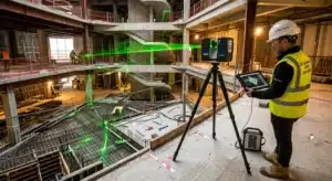
  2. Site Visit and Setup: Our scanning team will visit the site to set up the necessary equipment. This involves placing the 3D laser scanner in strategic locations to capture the desired areas accurately. We may also deploy additional control points or surveying techniques for validation purposes.
  3. Scanning: Once set up, our 3D laser scanner will capture millions of measurements per second, creating a dense point cloud representation of the scanned environment. We ensure comprehensive coverage of the desired areas, capturing both the external and internal details of structures.
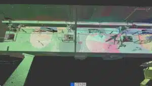
  4. Data Processing: After the scanning is completed, our team will process the collected data, which includes registering and aligning the individual scans to create a seamless point cloud. We may also perform additional processing steps to remove noise or unwanted elements from the point cloud.
  5. Modeling and Deliverables: From the processed point cloud, we can generate various deliverables based on the client’s requirements. This includes 3D models, virtual tours, cross-sections, as-built documentation, and more. We tailor the deliverables to meet the specific needs of each project.
  6. Quality Assurance: We conduct thorough quality assurance checks to ensure the accuracy and integrity of the captured data and deliverables. Our team reviews the generated models and documentation to verify that they meet the desired standards and specifications.
  7. Client Review and Collaboration: We involve our clients throughout the process, allowing them to review and provide feedback on the deliverables. This collaboration ensures that the final results align with their expectations and project goals.
  8. Project Completion: Once the deliverables have been finalized and approved by the client, we provide them with the necessary files and documentation. Additionally, we offer long-term archiving of the point cloud data for future reference if needed.

Throughout the entire process, our experienced team utilizes advanced laser scanning technology, industry-best practices, and expertise to deliver accurate and high-quality results. If you have further questions or would like to discuss your specific project requirements, please feel free to contact our team at Avian through our website or email.

Speak with the team at Avian to discuss your project needs. We love to solve complex problems using our combined knowledge and experience so let us know more about yours.