AEC Specialised Drone Services in Melbourne
From inspections to asset monitoring and project progress, Avian’s drone services in Melbourne help keep commercial construction projects moving efficiently and safely. With complete end-to-end project support and the latest drone technology, you can achieve higher-quality data and reporting without time-consuming planning and permits.
Professional Drone Services We Offer in Melbourne
Drone Photography and Video
Produce stunning aerial perspectives and 360 panoramic images to take your sales and marketing to the next levelwith our drone photography services in Melbourne.
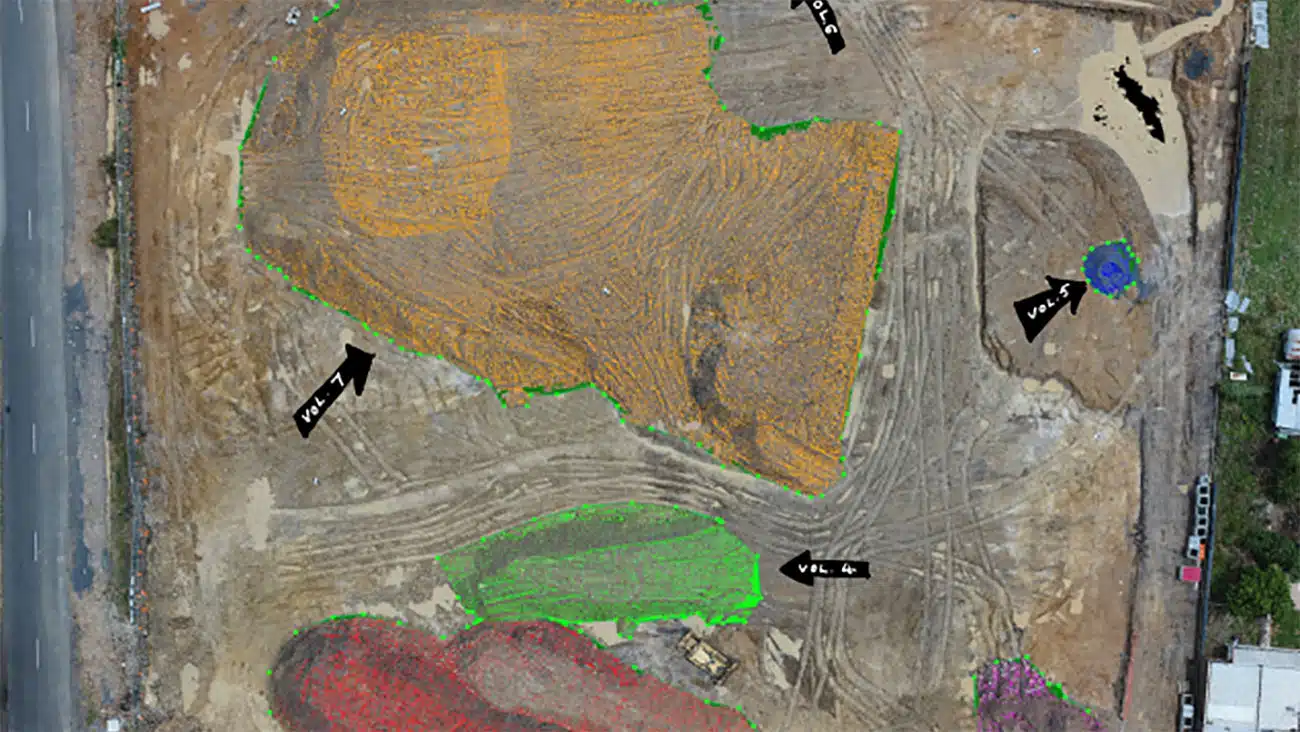
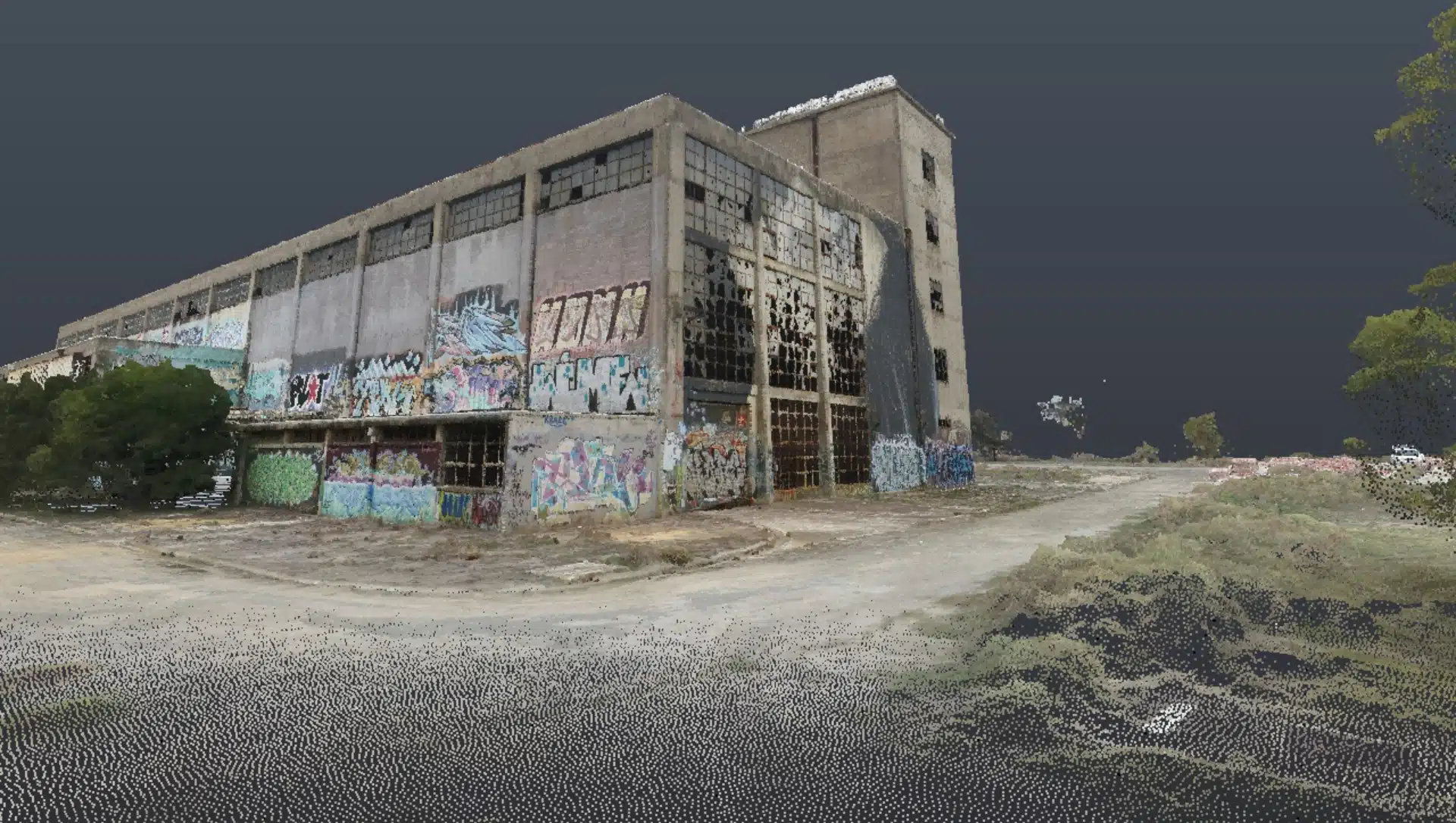
Terrain Mapping and 3D Models
Create precision digital twins of terrain, buildings, structures and interactive 3D models with accurate geometry for precise measurements, calculations and site engineering.
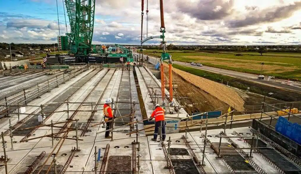
Aerial Drone Inspections
Achieve end-to-end project management of building facade inspection, bridge and tower assets, oil and gas facilities, and natural features for high–detail visual condition assessment and monitoring.
Data That Makes a Difference: Industry-Leading Inspections & Surveying with our Drone Services
Industry Leading | Safe Work Methods | Accurate Surveys | Reputable and Reliable
You no longer need to navigate months of planning, permits, and multiple rounds of approvals to conduct inspection activities. Our Melbourne drone inspection services and full building inspection services can help with on-site inspection, investigation, progress tracking, and site surveying with ease, making conducting visual inspections at heights, over water, or underneath bridges faster, safer, and more manageable.
While our drone camera can capture images and video in real time, it’s how we categorise and present data that makes all the difference. Avian Australia has developed a cataloguing and indexing methodology to provide meaningful data that can easily be referenced and reviewed for efficient desktop analysis and reporting. This often involves gathering and converting site information into 2D maps and 3D models using photogrammetry.
Some of the key drone services we offer in Melbourne include:
- Aerial inspections
- Land surveying
- Topographical maps
- 3D laser scanning and modelling
- Worksite inspection
- Geospatial maps and models
- Project Tracking – photography and video production


3D Laser Scanning

Digital Media

Aerial Surveying
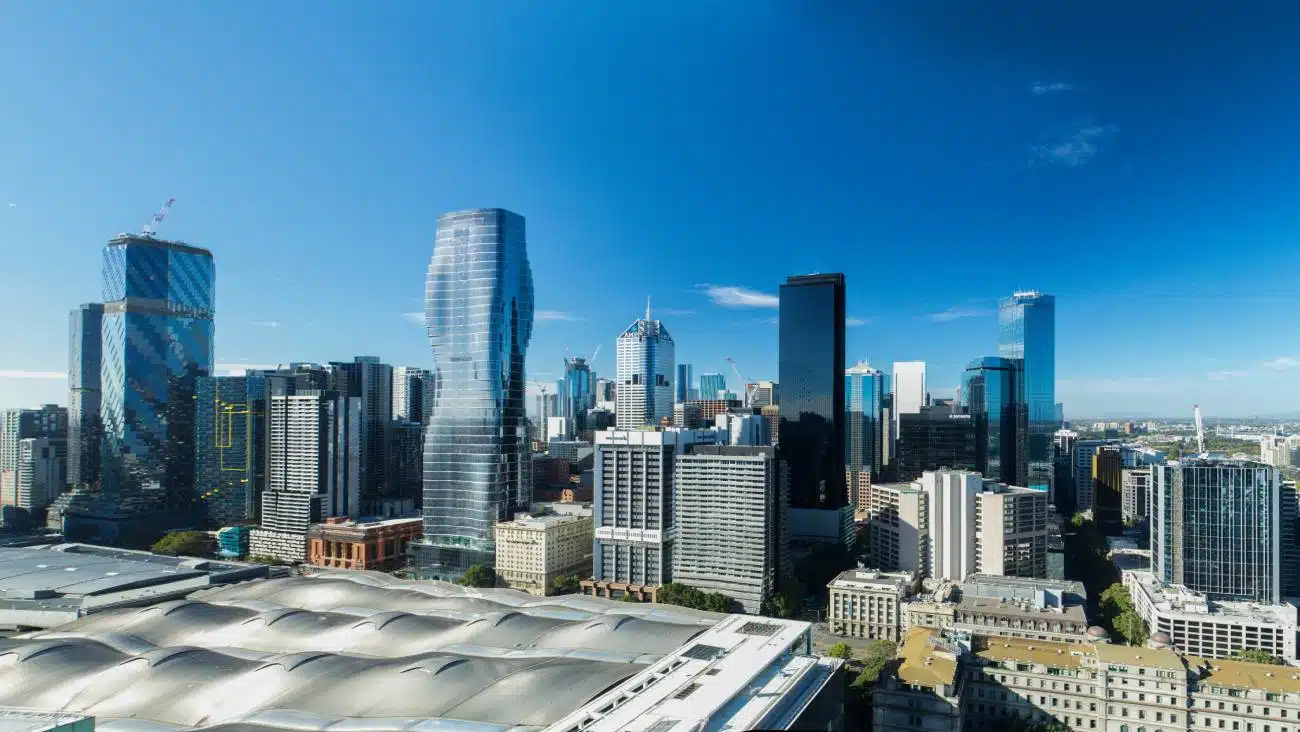
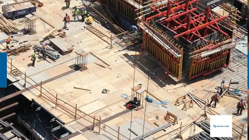
Melbourne Drone Services That Quickly Identify Asset Issues and Capture Site Data
Using a solid workflow and proven processes, drones can capture a substantial amount of data in a short timeframe. Their aerial perspective also provides project managers, engineers, and architects with information that cannot be gathered as cost-effectively or as quickly as without using drones.
Drones are increasingly used for investigative work, such as inspection, monitoring, and maintenance. When combined with drone surveying services and 3D laser scanning services, drones can provide aerial images to incorporate into point cloud data captured using laser scanners.
Using drones as part of asset management (including assessing existing conditions, inspecting structures and pipelines and conducting periodic inspections on machinery, facades and equipment for damages, corrosion, or leakage) improves planning, extends asset life and informs maintenance schedules. Our clients inform overall decision making to achieve objectives faster, safer and smarter than traditional methods.
Drones are increasingly used for investigation work like inspection, monitoring and maintenance activities. Also combined with surveying and 3D laser scanning processes the drones are able to provide aerial images that can be incorporated into point cloud data captured using laser scanners.
Asset management involves assessing existing conditions, inspecting structures, pipelines and conducting periodic inspections on machinery, facades and equipment etc. for damages, corrosion, leakage etc. Using drones as part of the inspection workflows improves planning, extends asset life and informs maintenance schedules. Our clients inform overall decision making to achieve objectives faster, safer and smarter than traditional methods.
Why choose Avian?
$20M Public Liability Insurance
Includes comprehensive Commercial coverage, Work Cover Insurance and Professional Indemnity cover.
Complete Worksite Safety
Our industry-leading Safe Work Methods guarantee mandatory compliance with Construction White Cards (CWCs) and Rail Industry Worker Cards (RIWCs) for access to sites throughout Victoria, including rail infrastructure and major construction projects.
Fully CASA-Licensed Operations
Our business and operators hold full CASA licensing, with approvals to conduct flights beyond standard operating conditions.
Advanced 3D Digital Visualisation
Our skilled data processing team specialises in laser scan data, providing drafting and design services through photogrammetry and 3D modelling software to deliver detailed 3D Revit models, terrain maps, and geospatial products.
Seamlessly Integrated into Existing Workflows
The 3D models and point cloud data we produce are fully compatible with GIS and BIM platforms, ensuring smooth integration into your current systems.
Statewide Coverage Across Victoria
We offer rapid deployment of drone services in Metro Melbourne (within hours) and extend to suburban and rural areas across Victoria within days.
Detect. Locate. Capture.
Our teams are able to offer drone services in Melbourne to multiple project sites in a day, capturing important site information for comprehensive reporting on the project progress, compliance and safety.
We also perform asset monitoring, provide construction updates, track contractor performance, offer 3D laser scanning and 3D surveying services, and ultimately ensure project success.
Some of our Drone Services Projects
Contact the Avian team today to discuss your drone services project
FAQs about Drone Services in Melbourne
We have answered some common questions AEC clients have about drone services in Melbourne.
Drone photography is more engaging and allows us to capture a site from more unique perspectives. Also, the aerial images and video are more visually impressive and capture the attention of the viewer due to the more interesting views.
Drone photography and videography are increasing in all market sectors, not just the more popular sectors like real estate and property. We are finding more traditional sectors and industries are utilising drone images and video to set themselves apart from the competition and to get their business noticed.
This depends on the distribution channels or uses of the images and video. We capture stunning aerial photography from helicopters, drones, balloons and EWPs (elevated work platforms) for our clients across Australia.
At Avian, we provide a full suite of digital media and visualisation services to clients, making their work easier. You can check out our drone services cost guide for more information on our pricing.
Of course, at Avian we have worked with AEC clients who collaborate with us for full end-to-end digital media and marketing as we also offer 360 photography, 3D visualisations, renders and full in-house video production. You can see some examples of our media work here.
We are experts in civil construction road projects and have strong experience working on major road projects for project updates, terrain mapping, surveying and monitoring site compliance and activity. We also use drones to detect contractor issues, track on site activity, ensure worksite safety and to provide regular project updates to clients.
You can learn more about how drones are used for road construction in this blog.
In our experience, these are the minimum requirements to ask when engaging a drone services provider:
- Access and site permits (CiWC)
- CASA Licenses (Remote Operators Certificate)
- Drone Registration Certificate
- Public Liability Insurance ($20 million)
- Workcover Insurance
- Evidence of equipment maintenance schedules
Our drone operators strictly adhere to industry safety standards and site-specific protocols. They hold all necessary certifications and conduct thorough pre-flight risk assessments to ensure safe operations around personnel and equipment. Mandatory use of Construction White Cards (CWC) and Rail Industry Worker Cards (RIWC) where required also helps maintain a secure work environment.
The duration varies depending on the size and complexity of the site, but most surveys or aerial photography sessions can be completed within a few hours. For larger or more detailed projects, multiple sessions may be scheduled to ensure comprehensive coverage.
Yes! The data we provide, including 3D models and point cloud files, is fully compatible with popular GIS (Geographic Information Systems) and BIM (Building Information Modelling) software, making it easy to incorporate into your existing workflows.
Yes, adverse weather, such as strong winds, heavy rain, fog, or poor visibility, can impact drone operations and image quality. We monitor weather conditions closely and schedule flights to ensure safe conditions and optimal results.