Bringing Precision to Life: 3D Scanning Melbourne
Architects and Engineers’ Trusted Partner
Over 1000 Satisfied Clients and Counting
3D Scanning That Delivers Fast, Precise Data Capture for Point Clouds!
On-site scanning
Using 3D laser scanners to capture on-site data. Applicable both for exterior and interior capture of buildings, bridges, roads, and more.
LiDAR surveying
Scan site volume, elevations and topography. Capture site data and convert it to point clouds and 3D models for digital visualisation.
CAD and Revit Models
We process laser scan point clouds into CAD/BIM software to generate 3D models of the built environment or terrain or draft 2D plans and drawings.
3D Scanning in Melbourne to Support Your Major Projects
Need for 3D Scanning in Melbourne
3D scanning is the process of measuring the built environment using laser scanning technology and converting these scans into digital 3D models. 3D scanners use laser light to scan any surface of a building and accurately capture its distance, shape and geometrics.
At Avian, we deliver quality 3D scanning services for architects, engineers and construction firms working on major commercial projects across Melbourne. These services include:
- Creating detailed 3D Models
- Inspection for civil engineering projects
- Assessing plant and machinery fit-outs
- Refurbishment and Renovations
- Monitoring site topography and geometry
- Defect identification, inspection and management
Located elsewhere in Australia? We also work with companies who require 3D scanning in Brisbane and 3D scanning services in Sydney.
Read more about the benefits and pitfalls of 3D laser scanning here before hiring 3D Laser Scanning Services
Got questions? Read our frequently asked questions here
")

Scan to BIM

Scan to Plan

Scan to Model
Why Choose High-Resolution 3D Scanning Services in Melbourne?
3D laser scanners, also known as LiDAR scanners save the raw data as point clouds. These point clouds consist of millions of data points which can be merged, manipulated, coloured and converted into different file formats.
The point cloud can be processed in CAD, BIM or visualisation applications depending on your unique project needs and outcomes.
From construction sites to warehouses and residential renovations, you can capture it all via our 3D laser scanning services in Melbourne.
Here are a few advantages of 3D laser scanning you should know about:
- Rapid and efficient data collection
- Minimises disruptions, maximises safety
- Eliminates the need for revisits
- Early detection of potential issues
- Assisting architects in flawless design
- Accurate assessment of existing conditions
- Real-time inspections brought to life
Get in touch with our team at Avian about 3D Scanning and we’ll take your project to the next level!
Lorem ipsum dolor sit amet, consectetur adipiscing elit. Ut elit tellus, luctus nec ullamcorper mattis, pulvinar dapibus leo.
Delivering Speed & Accuracy for Architecture, Construction & Engineering
Our 3D scans in Melbourne are utilised by numerous different roles and companies across major commercial projects and renovations. We equip architects with the comprehensive insight and detail required for precise work while empowering engineers to navigate complexity quickly and accurately. 3D scanning enhances construction efficiency, allowing builders, contractors, and project teams to confidently manage challenging site conditions with exactness.
From pre-construction through to completion and beyond, our 3d laser scanning and surveying services help you achieve greater precision, enhance safety measures, and reduce costs at every step of your project.

Why choose Avian?
$20M public liability coverage
All our work includes commercial protections, including WorkCover insurance and up to $1m professional indemnity.
100% Worksite safety
Our industry leading Safe Work Methods ensure mandatory CWCs and RIWCs to attend sites includes rail assets and large construction sites.
Quality Assurance
Qualified 3D laser scanning experts in Melbourne use surveying methods and equipment to ensure data quality and accuracy.
3D digital visualisation
Our data processing team is experienced processing laser scan data using photogrammetry and 3D modelling software to create 3D Revit models, 3D terrain maps and geospatial products.
Integrated with Existing Workflow
Our 3D models and point cloud data are compatible with GiS and BIM workflows and systems.
Pan VIC operations
3D scanning services deployed in Melbourne within hours, including the suburbs. Rural locations attended within days.
Revolutionizing Architectural Design: Comprehensive LiDAR Surveying and 3D Scanning Melbourne
LiDAR (light detection and ranging) is a remote sensing technology that uses laser light to measure distances and create detailed and accurate 3D representations of the surveyed area. It is commonly used in various industries such as surveying, mapping, construction, agriculture, and transportation.
LiDAR scanning offers numerous benefits to architects in various aspects of their work:
Accurate site measurements:
LiDAR scanning provides architects with highly accurate and detailed measurements of the site, including terrain, building structures, and surrounding objects. This helps in creating precise and reliable base maps for design purposes.
Capture of site details
LiDAR scanning captures a vast amount of data in a short span of time, including intricate site details such as facades, intricate architectural features, and vegetation. Architects can use this data to ensure accurate representation and preservation of existing elements in their designs.
Streamlining the design process
By using LiDAR scanning, architects can easily import the captured data into design software to create 3D models, aiding in the visualization and understanding of the site. This streamlines the design process by providing a comprehensive understanding of the existing conditions and allows for efficient decision-making.
Clash detection
By overlaying LiDAR data with new designs, architects can identify potential clashes or discrepancies between the proposed design and the existing site conditions. This helps in avoiding costly errors and modifications during the construction phase.
Improved project communication
LiDAR scanning allows architects to create accurate and visually appealing 3D representations of the site, which can be used to effectively communicate design ideas and concepts to clients, stakeholders, and construction teams. This enhances collaboration and ensures that everyone is on the same page regarding the project vision.
In summary, LiDAR scanning helps architects by providing accurate measurements, capturing detailed site information, speeding up the design process, facilitating clash detection, and improving project communication.
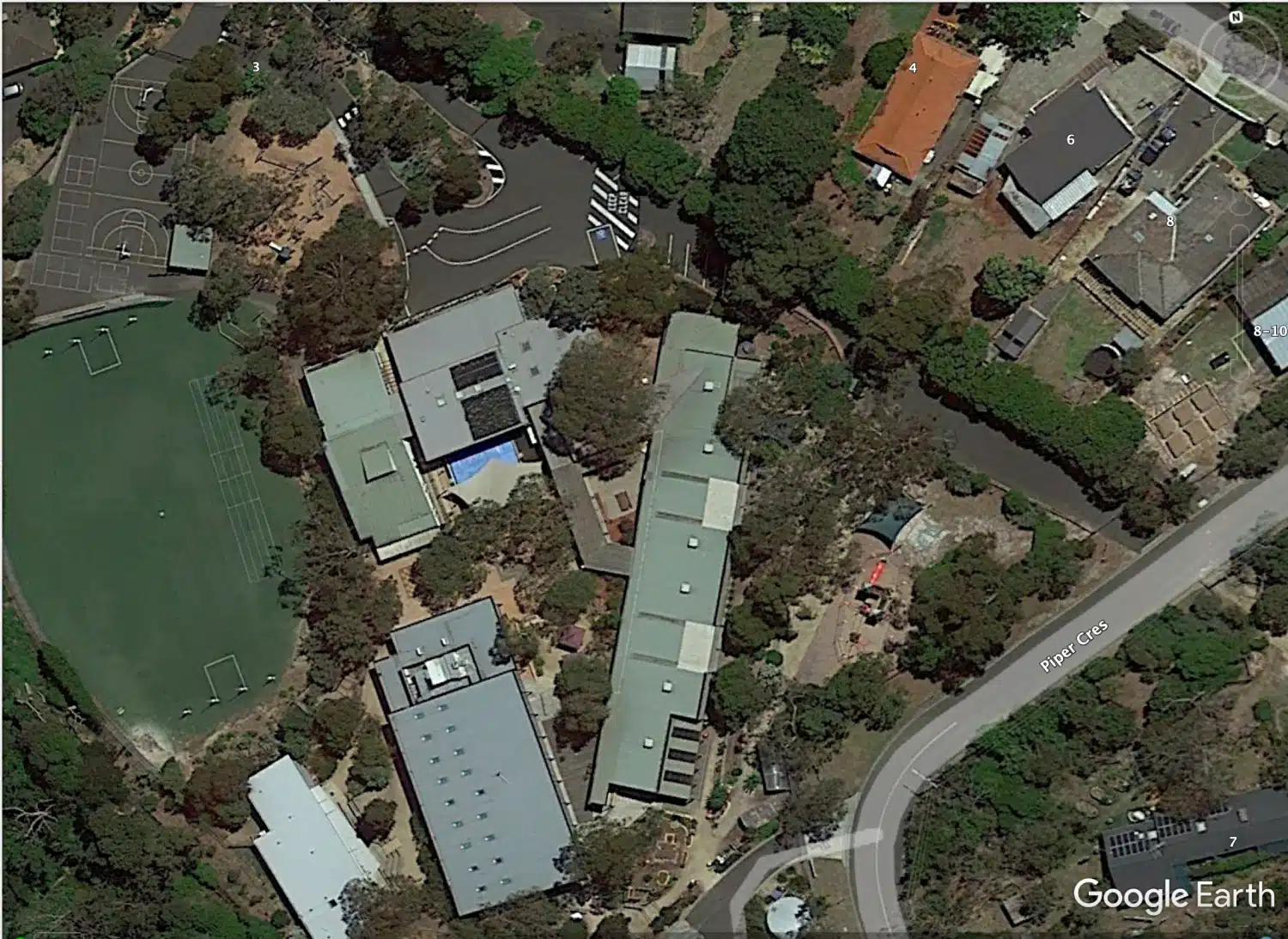
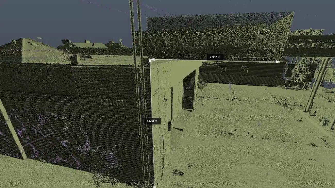
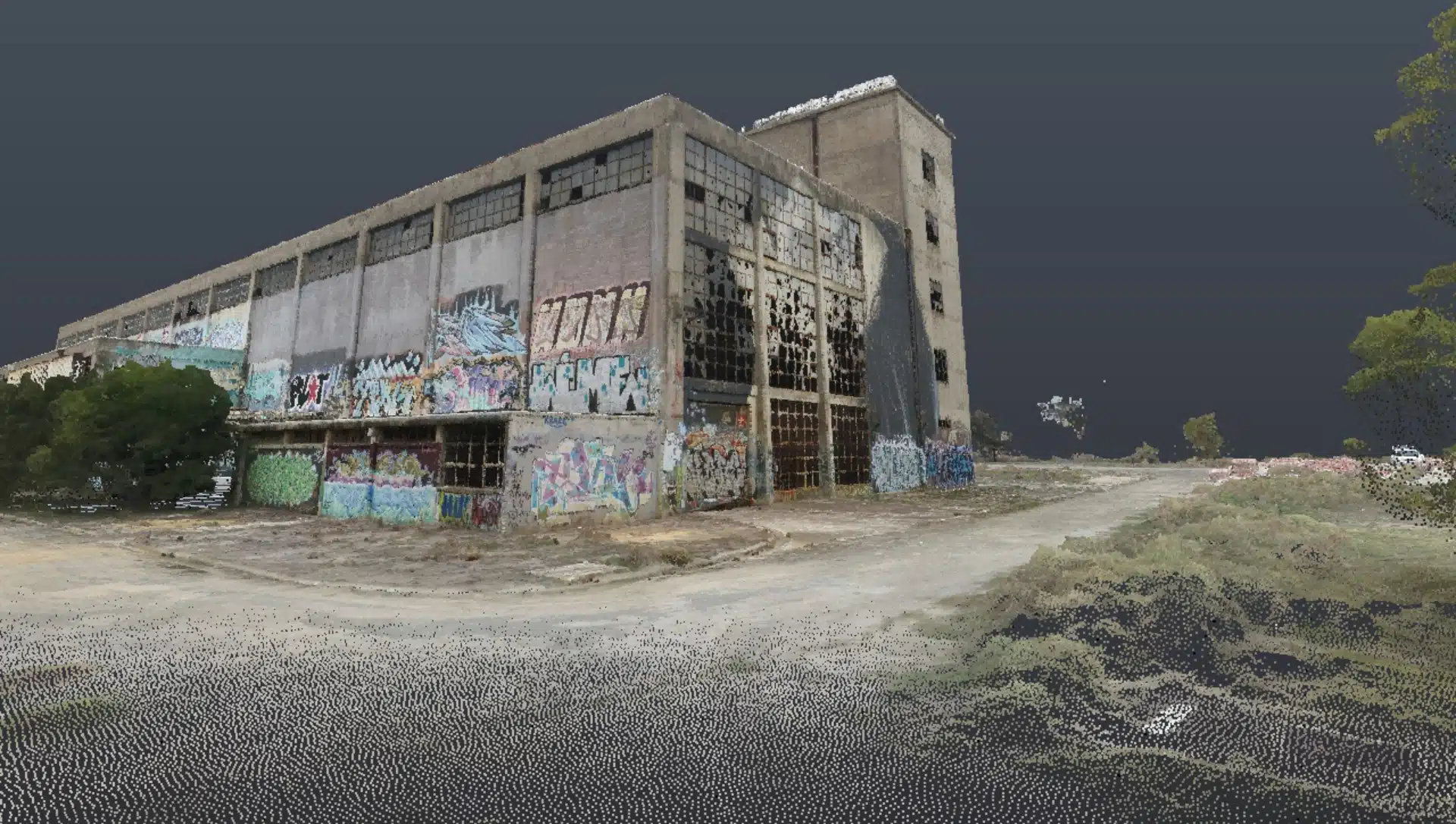
Our 3D Scanning Projects in Melbourne
Our Office in Melbourne
FAQs About 3D Scanning Services Melbourne
We have answered some common questions AEC clients have about 3D laser scanning services in Melbourne and across the state of VIC.
3D laser scanning services in Melbourne for Architecture, Engineering and Construction projects costs anywhere between $1600 – $2200 for a laser scanning technician to attend the site and scan. You can check out our laser scanning costing guide for more insights on how laser scanning is charged in Australia.
Depending on the size and shape of the building it usually takes us a day or two to scan both the interior and exterior of a large warehouse or commercial building. It takes longer to scan many rooms or internal details on the property i.e. HVAC.
You can check out this case study wherein our team conducted a scan to model a commercial warehouse scan to understand more about the process and benefits.
Using 3D Revit models allows for precision in design and installation as we are working with precision measurements from laser scanning. We are also able to create 2D drawings out of 3D Revit models so you can still obtain drawings with more efficiency and accuracy.
We create all types of plans and drawings- Floor plans, Reflected Ceiling plans and views-Elevation, Section. Basically everything from construction and shop drawings to updated as-built, BIM and asset management models.
3D scanning services in Melbourne are becoming increasingly popular among AEC professionals. This is because LiDARs offer better accuracy and convenience than traditional land surveying methods.
At Avian, we employ a comprehensive and strict quality management process:
- Our team of AEC professionals and land surveyors is experienced in surveying and laser scanning and understands the common pitfalls in this type of work.
- Using reliable and industry-leading scanning and surveying equipment and workflows.
- Quality control gateways of all data at key stages: acquisition, pre and post-processing and bespoke client reporting.
3D scanning services for Construction projects in Sydney and across NSW are a total game changer for the building and construction industry of the state. Using 3D scanning services, our land surveyors can assess and measure site conditions, determine volumes, track changes, and draft site plans for features, levels and breaklines.
During construction, we use interior 3D laser scanning for BIM, design and installation and updating site drawings. This helps project managers and contractors who have tight schedules and need to work with accurate site measurements and construction site monitoring information.
You can check out our blog on how 3D laser scanning in construction to know more.
We can deliver 3D models and drawings securely via our cloud in any file format. Melbourne 3D scan data is captured in point cloud and then converted to 3D models using BIM or CAD software. Typically, we provide 3D models to clients with Revit or CAD files but also files for applications like Microstation, Civil 3D and ArchiCAD.
Our 3D models are easily compatible with your existing workflow and software applications.
We need the client to provide us with a brief of the project and any supporting information (drawings/sketches) as to what surveys are required. We usually ask for these details from the client when they book a consultation.
Yes, 3D scanning is ideal for preserving detailed records of heritage sites and historic buildings. It captures accurate measurements and architectural features without physical contact, helping with restoration, conservation, and creating digital archives.
3D laser scanning provides millimetre-level accuracy and captures millions of data points quickly, offering a much more detailed and comprehensive dataset than traditional manual surveys, which rely on limited sample measurements.
Yes, 3D scanning is a non-invasive, quick process with flexible scheduling around site activities to minimise disruption. Our team coordinates closely with site managers to ensure scanning occurs safely and efficiently without impacting ongoing work.
3D scanning is widely used in construction, architecture, civil engineering, manufacturing, heritage preservation, and facility management. Any project requiring precise spatial data, as-built verification, or detailed site documentation can benefit from this technology.