Architect
High-Precision Land Surveying in Caulfield
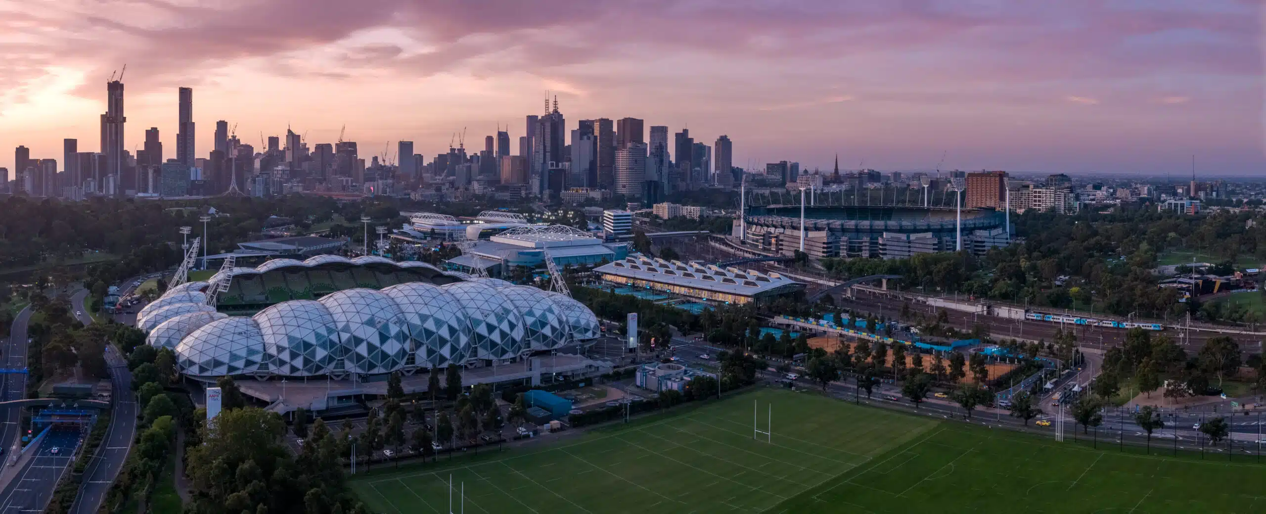
In the heart of Melbourne’s southeast, Caulfield is known for its leafy streets, historic villas on Hawthorn Road, and the legendary Caulfield Racecourse.
Tailored Land Surveying Service Caulfield
Every project in Caulfield, from heritage restorations in Caulfield North to contemporary townhouse complexes in Caulfield East, deserves a custom approach. Our land surveying service in Caulfield starts with a desktop review of historical plans and Glen Eira City Council overlays, followed by an on-site inspection to determine the ideal mix of GNSS control, total-station setups and 3D laser scanning for architecture, engineering, and construction.
This methodology guarantees that your certified boundary surveys, topographical plans and subdivision layouts conform to local regulations and suit Caulfield’s unique terrain.
Cadastral Surveys
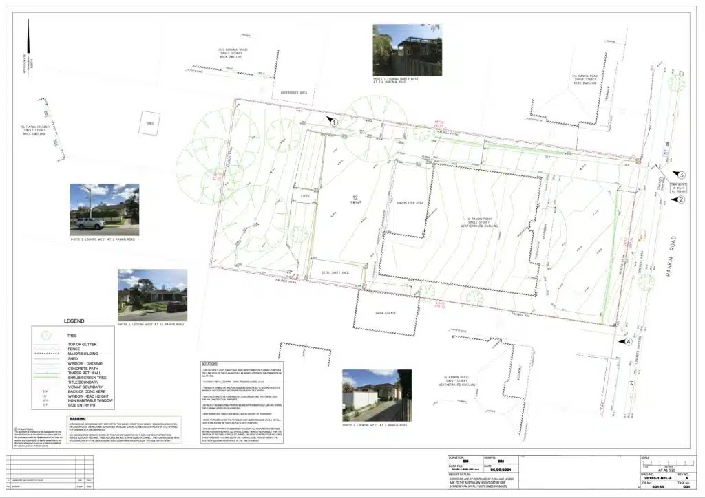
Used to define and amend property boundaries, resolve issues concerning land titles, and subdivision of existing land titles.
Feature and Levels Surveys
Used to help architects and builders with information of the subject site, the existing buildings, site features and services including adjoining road reserves and adjoining properties.
Site Analysis Surveys
Used to capture the neighbourhood and additional areas surrounding the site usually to around 50m radius. Helps architects identify features to include in the building design and required by council for town planning and building permit applications.
Tackling Caulfield’s Access Challenges
Fast and Reliable | Caulfield | Qualified Land Surveyors
Properties in Caulfield often back onto tight shared driveways or narrow service lanes. Setting up a tripod or GNSS rover in these confined spaces can be difficult, and line-of-sight instruments may be obstructed by fences or mature street trees. Our team for land surveys in Caulfield overcome these challenges by blending traditional total-station traverses with handheld scanners and drone surveying methods, ensuring every boundary, fence line and underground utility is mapped, even where access is limited.
Certified Boundary Surveys and Subdivisions
Accurate parcel lines are the cornerstone of any subdivision or title transfer. In Caulfield, where blocks can be as small as 150 sq m, even millimetre-level errors are unacceptable. Our cadastral land surveys in Caulfield verify fences, walls and service pits, and can incorporate underground utility mapping so your boundary plans stand up to Property Titles Office scrutiny. You gain peace of mind knowing property lines are exact and legally defensible.

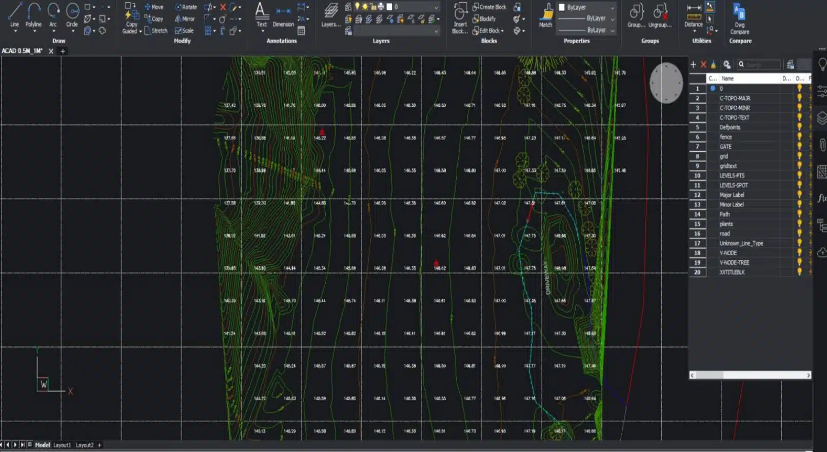
Detailed Topographical Mapping
Large-scale developments, like mixed-use buildings on Dandenong Road, require precise site elevations and contour data. Land surveying in Caulfield includes ground-based surveys supported by 3D surveys to produce high-resolution topographical maps. These deliverables highlight slope gradients, cut-and-fill volumes and vegetation cover, and integrate seamlessly with design platforms such as AutoCAD, Civil 3D, MicroStation and Revit. The outcome: you get clear terrain insights that drive smarter engineering decisions.
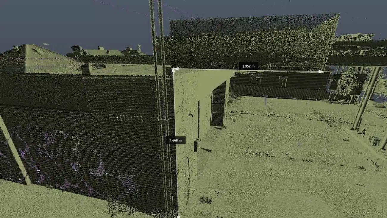
Advanced 3D Laser Scanning Integration
When you need more than 2D plans, our 3D scanning services in Melbourne, Sydney, Brisbane capture dense point clouds in minutes.
Picture scanning the façade of a heritage villa on Orrong Road without scaffolding, our laser scanners create millimetre-accurate point clouds, which our 3D laser scanning workflows convert into BIM-ready models and updated as-built drawings. This innovative approach slashes coordination time, catches clashes early and ensures your design aligns perfectly with site conditions.
Aerial Perspectives with Drone Surveying Services
From the sweeping lawns of Caulfield Park to the grandstands of Caulfield Racecourse, aerial data brings fresh insights. Drone surveying is part of our land surveying Caulfield services, this captures terrain, structures and vegetation in a single flight. These drones navigate tight urban spaces and shaded laneways, collecting photogrammetry and LiDAR data with minimal site disruption.
You benefit from rapid site analysis, progress monitoring and volumetric calculations, ideal for everything from public parks and reserve upgrades to residential developments.
")
Title Re-establishment Surveys

Feature and Levels Surveys

Large Land Area Surveys
Cost estimate for land surveying Caulfield
When you connect with our team, we will ask you a few fundamental questions about your project that help us to establish your unique needs. Some of these include:
- What are your objectives and the reasons you need these services?
- What are you seeking to achieve?
- Where are the site/s located?
- What are your timeframes and file formats?
- What are the next steps for you once we deliver our work?
Get in touch with us today to get a competitive quote for your next surveying project.
Complying with Glen Eira City Council Guidelines in Caulfield
With a blend of high-density housing, narrow laneways and thriving commercial strips along Glen Eira Road, obtaining precise site data can be tricky. Avian’s land surveying Caulfield service combines local insight with cutting-edge techniques to deliver accurate results, whether you’re subdividing a block off Kooyong Road or planning a mixed-use development near Caulfield Park.
Before any construction, renovation or alteration on your property, it’s crucial to confirm local council requirements from Glen Eira City Council:
Glen Eira City Council
15 Baxter Road, Bentleigh East VIC 3165
Phone: (03) 9524 3333
Website: www.gleneira.vic.gov.au
Our land surveying Caulfield team can manage the permit process, ensuring your surveying complies with all local and state regulations and keeps your project compliant and on schedule.
Why choose Avian?
$20M public liability insurance
Includes comprehensive Commercial coverage, Work Cover Insurance and Professional Indemnity cover.
100% Worksite Safety
Our teams all hold valid CWCs and RIWCs to work in construction and rail project worksites safely.
Qualified and Experienced Land Surveyors
Our surveyors are both Licensed and Qualified for Cadastral Land Surveying and a minimum 10 years industry experience.
Obtain more with less
We not only provide 2D plans and 3D Models but also deliver more site context and visualisation in the form of 360 virtual tours and architectural renders.
Easily integrated to existing workflows
The data we provide is compatible with your existing workflow systems like CAD, Revit, Civil3D and Microstation
Across Melbourne and country Victoria
Our land surveying services are available within days and across Victoria within a week of a confirmed booking.
Precision-driven land surveying in Caulfield
Land Surveying is a centuries-old profession that has evolved to incorporate leading innovation and digital technologies to deliver faster and more accurate observations and measurements including the ability to provide more site information that ever before.
Our team uses a combination of geospatial, surveying and 3D laser scanning methods to capture onsite conditions faster, safer and smarter when compared to the traditional land surveying methods typically used across Melbourne and Victoria.
Here are a few key differences in the way we conduct surveys to ensure maximum value for our clients:
- Millions of data points captured onsite
- Faster onsite attendance and workflows
- Qualified and experienced surveying, laser scanning, geospatial and modelling expertise
- More onsite data supplied to clients including site analysis and neighbourhood context
- Short and long term monitoring of assets and existing conditions
- Multiple outputs available in both 2D and 3D formats including GiS applications
- Increased site context means better planning and decision making
- Improve planning and permit applications with more detailed information
- Increased client engagement from 3D visualisations and site tours
- Promote project success and improve future bids with project profile and case studies
Seamless Workflow Integration
We deliver survey data in formats that slot directly into your existing systems. Whether you’re using CAD, Civil 3D, MicroStation or Revit, our plans, point clouds and 3D models integrate smoothly, saving you time on file conversion and data cleanup.
Clients who need land surveys in Brighton, Ballarat, and Brunswick can expect the same consistency and quality, region after region.
Our Land Surveying Projects
Local Expertise and Fast Mobilisation
Based in Caulfield, our survey crews understand local soils, weather patterns and council processes. We deploy teams across Caulfield North, Caulfield South, Glen Huntly and beyond, often on short notice. This local footprint guarantees fast response times and expert advice at every stage, from initial briefing to final deliverables.
Popular Melbourne Metropolitan Area and Inner Suburbs We Cover
Contact the Avian today to discuss your land surveying project
Ready to Secure Precise Site Data with Surveying in Caulfield?
For industry-leading land surveying services in Caulfield, as well as advanced 3D laser scanning, and reliable drone surveys, trust Avian. Let our local experts turn your site data into actionable insights, streamlining design, approvals and construction.
Contact Avian today to discuss your requirements and schedule your on-site consultation.
FAQs for Avian's Land Surveying in Caulfield
We have answered some common questions that AEC clients have about our land surveying services in Caulfield.
A combination of boundary (cadastral), feature-and-level (topographical) and site analysis surveys ensures you capture legal property lines, elevation profiles and key site features for informed design and approvals.
Send us your project brief, site address and any available plans. We’ll arrange a site visit to define scope, methodology and timelines before providing a detailed proposal for any land surveying service in Caulfield.
Yes, our building inspection services include ground-penetrating radar alongside traditional surveying to accurately locate pipes, drains and cables, even in narrow access ways.
Our integrated approach combines terrestrial surveys, 3D laser scanning and drone LiDAR in a single workflow, delivering comprehensive data for complex urban sites.
If your flight operates within 100 m of public events, council facilities or busy pedestrian zones, Glen Eira City Council approval is mandatory. We handle the entire application for you.
Our local team can be on-site within hours, ensuring minimal project delays, whether you’re off Gardenvale Road or tucked away near Elsternwick. Contact us for further information.