Services > 3D Laser Scanning
3D Laser Scanning: Your Solution for Precision
Being one of the foremost 3D laser scanning companies, our services offer unparalleled precision in as-built drawings and exhaustive site analysis for the AEC industries. Leverage our cutting-edge technology and expertise to execute your projects with confidence and efficiency.
Site Measure Up
Get accurate 2D drawings and 3D models with detailed site analysis, along with architectural visualisations and renders.
Resolve uncertainties in interior dimensions and unclear site details for seamless project management and execution.
Improve planning and design accuracy to maximise the interior spaces.
Expedite the planning and design process.
Engineering Drawings
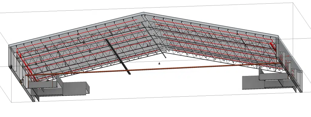
Receive updated as-built drawings, 3D models, and 3D DWG models for structural and detailed analysis.
Address uncertainties in dimensions, alignment and obtain key details of inaccesible areas, accelerating engineering and design projects.
Improve budget management, cost avoidance and maintenance planning.
As-Built Surveys
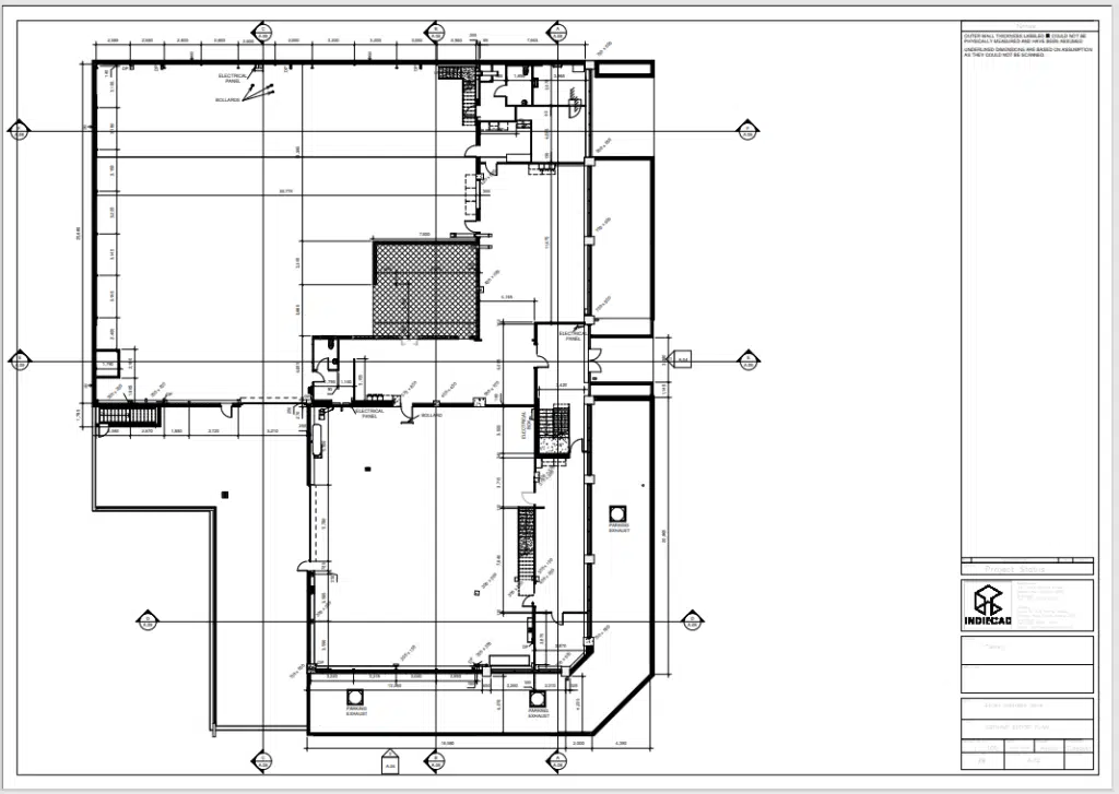
Obtain updated as-built drawings and 3D Revit Models for comprehensive site analysis and spatial awareness.
Eliminate guesswork in dimensions and measurements, obtain precise site information, ensuring project accuracy and success.
Proactively identify clashes and address issues before they impact project timelines.
Calculate Nett Lettable Area (NLA) and Gross Lettable Area (GLA) for leasing and sales.
Avian has a Proven Pathway to Precision in As-Built Surveys

At Avian Australia, we believe in precision from the ground up. Our meticulous site assessment and validation process is a testament to our commitment to excellence and starts at the initial consultation.
Initial Groundwork: We commence with a thorough site assessment, diving deep into the specifics of your site and project. Our experts ensure that every detail is spot-on, laying the foundation for delivering above expectations.
Architectural Mastery: Leveraging our architectural prowess, we analyze every facet of the site. This rigorous analysis culminates in the crafting of detailed architectural set drawings tailor-made for project success.
Engineering Drawings: From our expertise with obtaining a precision site scan and quality assured point cloud data, we draft the 2D or 3D CAD and Revit models obtaining a clear and concise model of the structure.
Post-Construction Excellence: Once the construction phase concludes, we don’t just stop there. Our As-Built Surveys are essential to ensuring that reality reflects the design. Has the contractor delivered according to specification? Every deviation is noted, ensuring you’re always in the know, supported by invaluable evidence.
Our streamlined process isn’t just about following steps; it’s about guaranteeing certainty, using unparalleled accuracy, and ultimately, ensuring the timely success of your project.
Explore our 3D Laser Scanning FAQs for more insights.
Ready to experience the difference with one of the best 3D laser scanning companies? Choose Avian Australia.
Choose Avian Australia -
A Leader Among 3D Laser Scanning Companies
For those seeking unparalleled precision, meticulous detail, and unwavering reliability, our 3D Laser Scanning services are the optimal choice.
✓ Comprehensive Site Analysis
A thorough understanding of your site’s specific characteristics is crucial for the successful execution of any project. Our 3D Laser Scanning service provides an exhaustive site analysis, capturing even the most minute details. This comprehensive site data enables you to make well-informed decisions throughout the planning, design and construction phases. A digital twin of your building or asset is accessible for myriad of uses, trades, contractors and consultants in future.
✓ High-Quality Architectural Visualizations and Renders
Our service extends beyond mere measurements to include superior architectural visualizations and renders. These impressive visual aids allow you to preview the design concept and project outcome, thereby facilitating client presentations, engagement and early identification of potential design challenges.
✓ Digital Assets: 3D Revit Models and DWG Files
In today’s architectural, engineering, and construction (AEC) sectors, digital assets such as 3D Revit Models and DWG files are of paramount importance. Our 3D Laser Scanning service delivers these digital assets, tailored to your specific requirements. These files are designed to integrate seamlessly into your existing workflow, thereby enhancing the efficiency of your design and planning process.
✓ Precise and Updated As-Built Drawings
Eliminate the reliance on outdated or imprecise blueprints. Our advanced 3D Laser Scanning and surveying services delivers current as-built drawings that are an accurate reflection of existing conditions. This level of precision is indispensable for mitigating costly errors and unnecessary revisions in architectural, engineering, and construction projects.
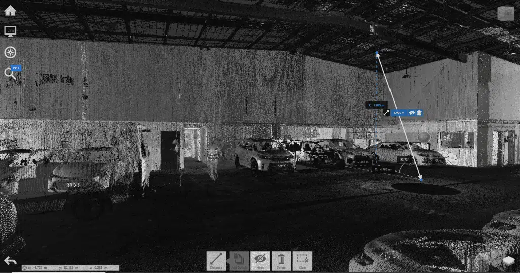
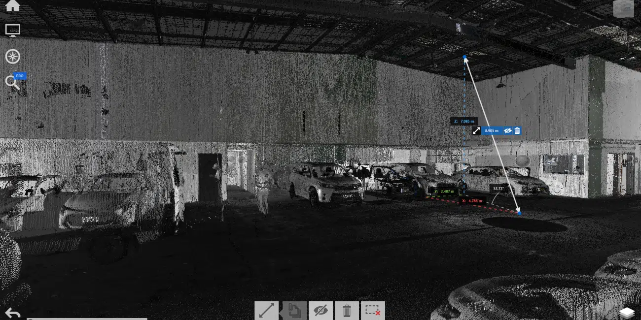
Our team at Avian meticulously scans interiors of a 10 Storey Secure Car Park in Melbourne CBD using 3D laser scanning technology.
Our team at Avian meticulously scans interiors of a 10 Storey Secure Car Park in Melbourne CBD using 3D laser scanning technology.
Experience the distinctive precision that sets us apart in the realm of 3D laser scanning companies
FAQs about 3D Laser Scanning
We’ve compiled answers to some common questions that clients often have about the 3D Laser Scanning process and the services offered by Avian Australia, one of the foremost 3D laser scanning companies.
The cost to 3D scan an item can vary depending on various factors such as the complexity and size of the item, the level of detail required, and the location of the scanning service provider. However, as per our laser scanning costing guide, upwards 3D laser scanning services in Melbourne start from $1500 for a surveyor to attend the site and perform the scan. For more detailed pricing information and package inclusions, I recommend checking out our pricing page or contacting our team directly through our contact us page at www.avian.net.au/contact-us.
Yes, LiDAR is a type of 3D laser scanning technology. LiDAR scanners use laser light to capture millions of measurements per second and create a point cloud, which can then be used to replicate and analyze the scanned environment in 3D.
LiDAR can be used in various situations depending on the specific requirements of your project. Here are some common scenarios where LiDAR is beneficial:
- Topographic surveys: LiDAR is used to accurately capture detailed elevation data and create high-resolution topographic maps. It provides a comprehensive view of the terrain, including hills, valleys, and other land features.
- Infrastructure monitoring: LiDAR can be employed to monitor the condition and movements of infrastructure assets such as bridges, dams, and towers. It helps detect any deformations or changes over time, allowing for proactive maintenance and ensuring safety.
- Forestry and vegetation analysis: LiDAR can penetrate dense vegetation and capture detailed information about tree height, canopy density, and biomass. This data is useful for forest management and environmental studies.
- Flood modeling and analysis: LiDAR can accurately measure the elevation of land areas and water bodies. This data is crucial for flood modeling and analysis, allowing for better floodplain mapping and planning for flood mitigation measures.
- Archaeological surveys: LiDAR can reveal hidden archaeological features and structures by capturing detailed 3D information of the terrain. It aids in identifying potential sites and planning excavations.
- Urban planning and development: LiDAR is used to capture urban environments in 3D, providing accurate data for urban planning, development, and infrastructure design. It helps in creating detailed digital models of cities and analyzing the impact of proposed changes.
These are just a few examples of when LiDAR can be utilized. It’s important to assess your project’s specific requirements and consult with professionals to determine if LiDAR is the appropriate technology for your needs.
The main difference between 3D laser scanning and photogrammetry lies in the technology used to capture data.
3D laser scanning, as mentioned earlier, uses laser light emitted from a scanner to capture millions of measurements per second, creating a point cloud representation of the scanned environment. It is highly accurate and can provide detailed information even from long distances. Laser scanning is often utilized for capturing as-built structures, objects, and large areas.
On the other hand, photogrammetry relies on capturing and processing digital images or footage from drones or other cameras. These images are then fed into photogrammetry software, where algorithms analyze the images and triangulate points to generate 3D models and maps. Photogrammetry is effective in capturing detailed visual information and is often used for site design, land layout, and infrastructure planning.
In summary, 3D laser scanning is focused on capturing precise measurements using laser light, while photogrammetry emphasizes the generation of 3D models from digital images. Both technologies have their advantages and can be used in different scenarios depending on the requirements of the project.
Certainly! Avian, one of the leading 3D laser scanning companies, follows a well-defined workflow for 3D laser scanning projects:
- Project Planning: We work closely with our clients to understand their project requirements, objectives, and constraints. This includes determining the scope of the scanning project, specific areas to be scanned, and any specific deliverables needed.
- Site Visit and Setup: Our scanning team will visit the site to set up the necessary equipment. This involves placing the 3D laser scanner in strategic locations to capture the desired areas accurately. We may also deploy additional control points or surveying techniques for validation purposes.
- Scanning: Once set up, our 3D laser scanner will capture millions of measurements per second, creating a dense point cloud representation of the scanned environment. We ensure comprehensive coverage of the desired areas, capturing both the external and internal details of structures.
- Data Processing: After the scanning is completed, our team will process the collected data, which includes registering and aligning the individual scans to create a seamless point cloud. We may also perform additional processing steps to remove noise or unwanted elements from the point cloud.
- Modeling and Deliverables: From the processed point cloud, we can generate various deliverables based on the client’s requirements. This includes 3D models, virtual tours, cross-sections, as-built documentation, and more. We tailor the deliverables to meet the specific needs of each project.
- Quality Assurance: We conduct thorough quality assurance checks to ensure the accuracy and integrity of the captured data and deliverables. Our team reviews the generated models and documentation to verify that they meet the desired standards and specifications.
- Client Review and Collaboration: We involve our clients throughout the process, allowing them to review and provide feedback on the deliverables. This collaboration ensures that the final results align with their expectations and project goals.
- Project Completion: Once the deliverables have been finalized and approved by the client, we provide them with the necessary files and documentation. Additionally, we offer long-term archiving of the point cloud data for future reference if needed.
Throughout the entire process, our experienced team utilizes advanced laser scanning technology, industry-best practices, and expertise to deliver accurate and high-quality results. If you have further questions or would like to discuss your specific project requirements, please feel free to contact our team at Avian through our website or email.
Speak with the team at Avian to discuss your project needs. We love to solve complex problems using our combined knowledge and experience so let us know more about yours.