Land Surveying Services in Doncaster
Cadastral Surveys
Used to define and amend property boundaries, resolve issues concerning land titles, and subdivision of existing land titles.
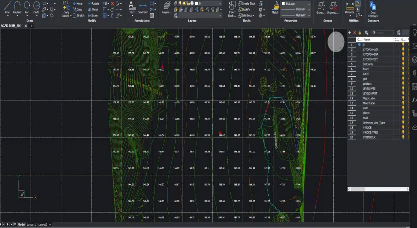
Feature and Levels Surveys
Used to help architects and builders with information of the subject site, the existing buildings, features and services including adjoining road reserves and adjoining properties.
Site Analysis Surveys
Used to capture the neighbourhood and additional areas surrounding the site usually to around 50m radius. Helps architects identify features to include in the building design and required by council for town planning and building applications.
Discover the ease of Professional land surveying in Doncaster!
Fast and Reliable | Doncaster | Qualified Land Surveyors
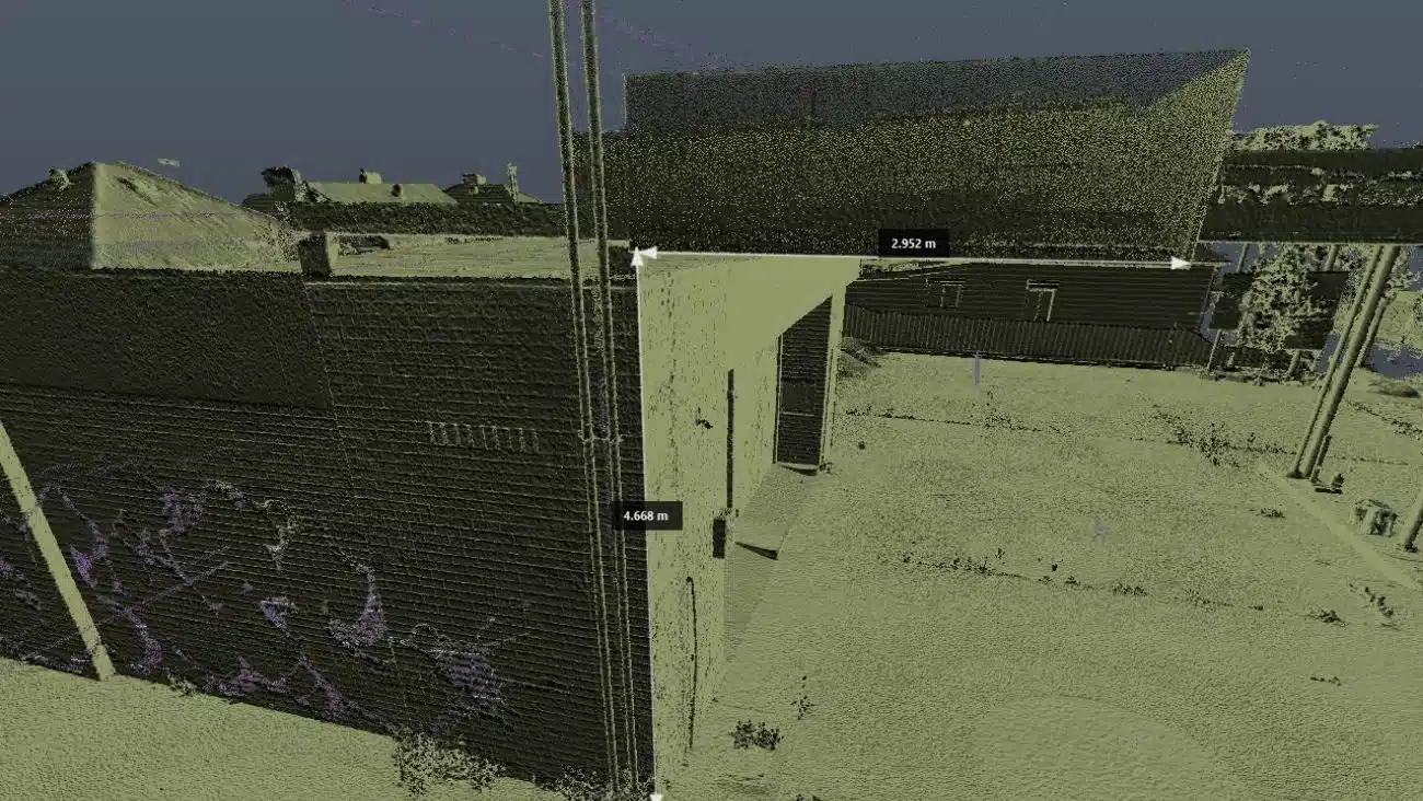
At Avian, we use a combination of surveying, laser scanning and digital visualisation techniques to make the land surveying and 3D visualisation process faster, safer and more accurate.
We help clients through key stages of the design and construction process with surveying services:
- Cadastral Surveys: to identify the site location and mark title boundaries.
- Site Analysis Surveys: to conduct site analysis and provide neighbourhood context within a 50m radius of the property.
- Feature and Levels Surveys: to provide information on the site buildings and features, including adjoining road reserves and building features within 9m radius. We specialise in large land area surveys of farms, agricultural and commercial properties.
- Dilapidation Surveys: Provides a visual assessment of cosmetic or structural defects of the subject property recorded in a comprehensive condition report with defects and issues clearly referenced. The survey is conducted before or after construction, demolition or capital works to identify changes in the inspected areas and provides a documented account for further actions.
- Lettable Area Surveys (NLA/GLA): To assess the lettable area in a building for calculating rent, valuations or supporting lease negotiations. This is conducted in accordance with the Property Council of Australia – Method of Measurement Guidelines.
- Measured Building or As-Built Surveys: to measure existing buildings (both interior or exterior) for renovation, fit-out or commercial leasing of offices, malls, residential buildings and warehouses. We provide drafting and 3D modelling for basic 2D floor plans to highly detailed 3D Revit and CAD models.
- Building and Construction Setout Surveys: Establish onsite markings for buildings for residential and commercial construction or extensions based on design specifications. This includes civil works for construction such as roads, services, boreholes and buildings.
- Monitoring Surveys: to detect surface movement with short/long term monitoring of buildings.
- Engineering surveys: to conduct detailed surveys of water, sewer lines, drains, roads, telco networks, mines as well as earthworks and volumetric calculations. Using the latest in drone and geospatial techniques we provide digital terrain models, elevations, watershed analysis, feature extraction, vegetation and terrain modelling.

")
Title Re-establishment Surveys

Feature and Levels Surveys

Large Land Area Surveys
Cost estimate for land surveying Doncaster
When you connect with our team, we will ask you a few fundamental questions about your project that help us to establish your unique needs.
- What are your objectives and why do you need this service?
- What are you seeking to achieve?
- Where are the sites located?
- What are your timeframes and file formats?
- What are the next steps once we deliver our work?
Get in touch with us today to get a competitive quote for your next surveying project.
Why choose Avian?
$20M public liability insurance
Includes comprehensive Commercial Coverage including Work Cover Insurance and to $1m professional indemnity cover.
100% Worksite Safety
Our teams all hold valid CWCs and RIWCs needed to safely work in construction and rail project worksites.
Qualified and Experienced Land Surveyors
Our surveyors used are both Licensed and Qualified for Cadastral Land Surveying and a minimum 5 years industry experience in land surveying.
Obtain more with less
We don’t only provide you with 2D plans but can deliver more site context and value add in the form of 360 virtual tours, 3D Models or Architectural Renders.
Easily integrated to existing workflows
The data we provide is compatible with your existing workflow systems including applications like CAD, Revit, Civil3D and Microstation
Across Melbourne and country Victoria
Our land surveying services are attended within hours and across Victoria within a week of a confirmed booking.
Precision-driven land surveying in Doncaster
Land Surveying is a centuries-old profession that has evolved to incorporate leading innovation and digital technologies to deliver faster and more accurate observations and measurements including the ability to provide more site information that ever before.
Our team uses a combination of geospatial, surveying and 3D laser scanning methods to capture onsite conditions faster, safer and smarter when compared to the traditional land surveying methods typically used across Melbourne and Victoria.
Here are a few key differences in the way we conduct surveys to ensure maximum value for our clients:
- Millions of data points captured onsite
- Faster onsite attendance and workflows
- Qualified and experienced surveying, laser scanning, geospatial and modelling expertise
- More onsite data supplied to clients including site analysis and neighbourhood context
- Short and long term monitoring of assets and existing conditions
- Multiple outputs available in both 2D and 3D formats including GiS applications
- Increased site context means better planning and decision making
- Improve planning and permit applications with more detailed information
- Increased client engagement from 3D visualisations and site tours
- Promote project success and improve future bids with project profile and case studies
Our Land Surveying Projects
Popular Melbourne Metropolitan Area and Inner Suburbs We Cover
| land surveyor ballarat | land surveyor daylesford | land surveyor phillip island | land surveyor pakenham |
| land surveyor bendigo | land surveyor melton | land surveyor colac | land surveyor mornington |
| land surveyor ballarat | land surveyor kyneton | land surveyor castlemaine | land surveyor greensborough |
| land surveyor werribee | land surveyor rockbank | land surveyor shepparton | land surveyor bacchus marsh |

Contact the Avian today to discuss your land surveying project
FAQs about Land Surveying in Doncaster
We have answered some common questions that AEC clients have about our land surveying services in Doncaster.
Land surveying in Doncaster starts around $1200. However, the cost of land surveying depends on a range of factors including existing surveys in the area, the size and location of the property and existing conditions and features that makes it difficult to access the subject site.
We can provide a detailed and accurate cost estimate once we have an address to conduct some due diligence on the property. You can book a no obligation free consultation and tell us about your land surveying requirements.
We conduct an investigation about the property titles and history before quotation to ensure we correctly assess the complexity and required time onsite. Some properties may not have had a land survey completed in a long time and therefore it takes longer to establish the baselines to work from. In other cases, there are difficulties with accessing areas of the property due to trees, vegetation or structures making it difficult to take measurements on all property boundaries.
The land surveyor will attend the property and establish the existing property boundaries and features using precision surveying equipment. This involves taking site measurements called observations and checking the property boundaries, fence lines, topography features and the proximity to adjacent properties. As you can imagine, it takes time to ensure the measurements are accurate and equipment is correctly positioned to avoid any disputes or errors from the results.
In our experience, there are many challenges with land surveying but mostly difficulty with site access that causes our work to be more complicated. Aside from technical issues that occur from time to time our main concern is to ensure the safety and well being of our team while in the field.
We would recommend builders to conduct a cadastral and feature and levels survey before starting the construction project. A cadastral survey is used to define the property boundaries and verify land titles and can only be completed by a licensed cadastral surveyor.
Other than that, we also advise builders to invest in topographical surveys, sub-division surveys, dilapidation and site analysis surveys to get more information of the property for design and planning purposes.