Manual measuring has always been the bottleneck in producing accurate floor plans. A tape measure misread by 20mm becomes a structural clash, a costly variation – or worse, a building that doesn’t meet its as-built record.
3D laser scanning floor plans eliminates that risk entirely, replacing guesswork with verified spatial data captured to within ±1–3mm of reality.
For construction companies, engineers, developers, and facilities teams across Australia, this isn’t just a faster way to document a building. It’s a fundamentally more reliable one.
Why Accuracy is Everything
Traditional site measuring involves walking a building with a tape, laser distance meter, or total station, documenting room by room, wall by wall. The process is time-intensive, prone to cumulative error, producing a result that’s only as good as the last measurement taken.
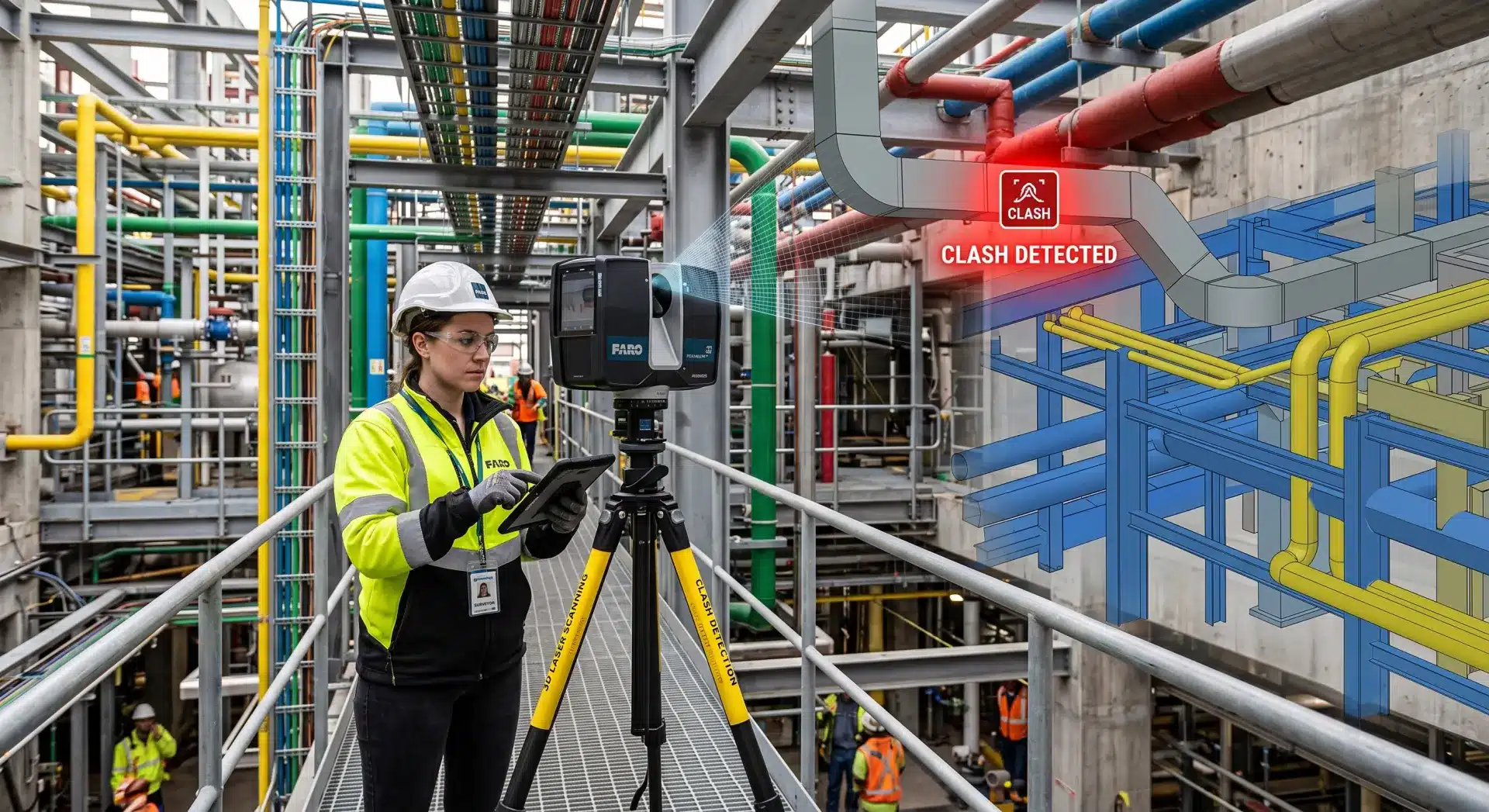
3D laser scanning works differently. A scanner is positioned at multiple points throughout a building, emitting millions of laser pulses per second that bounce off every surface and return a precise distance reading.
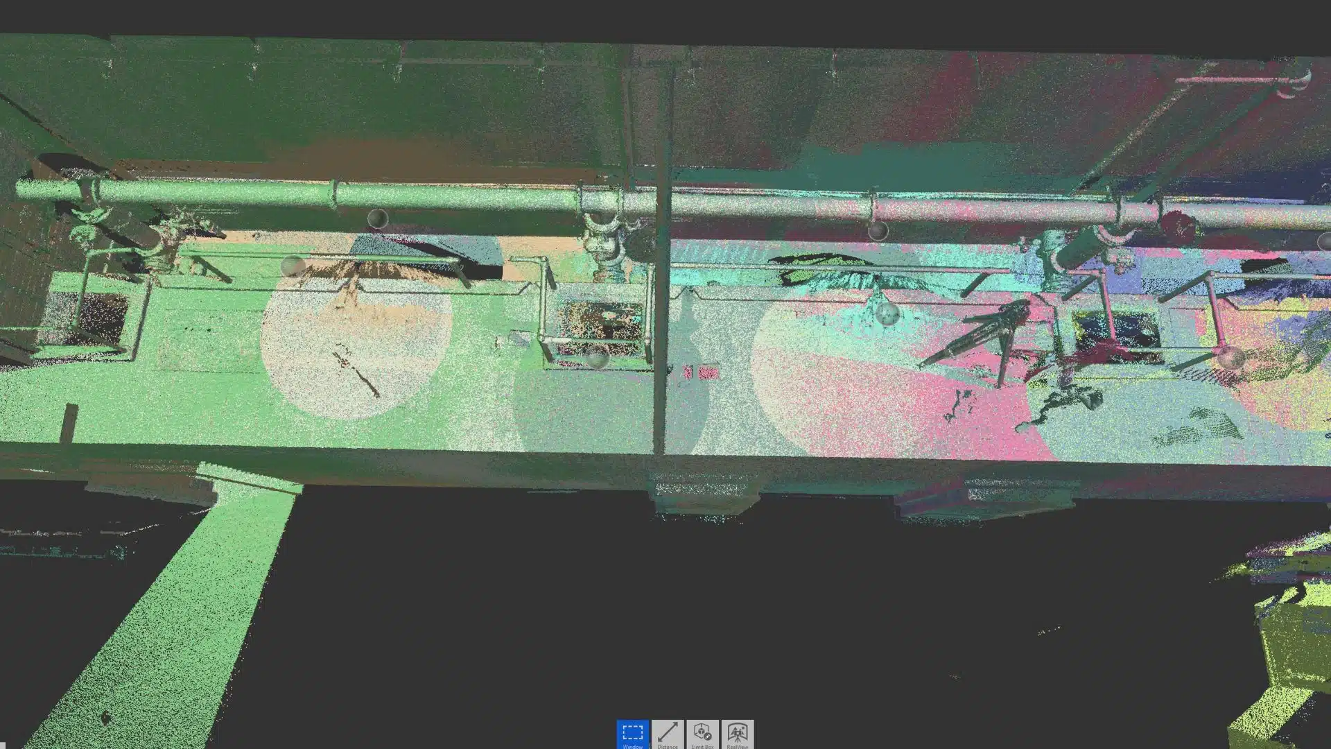
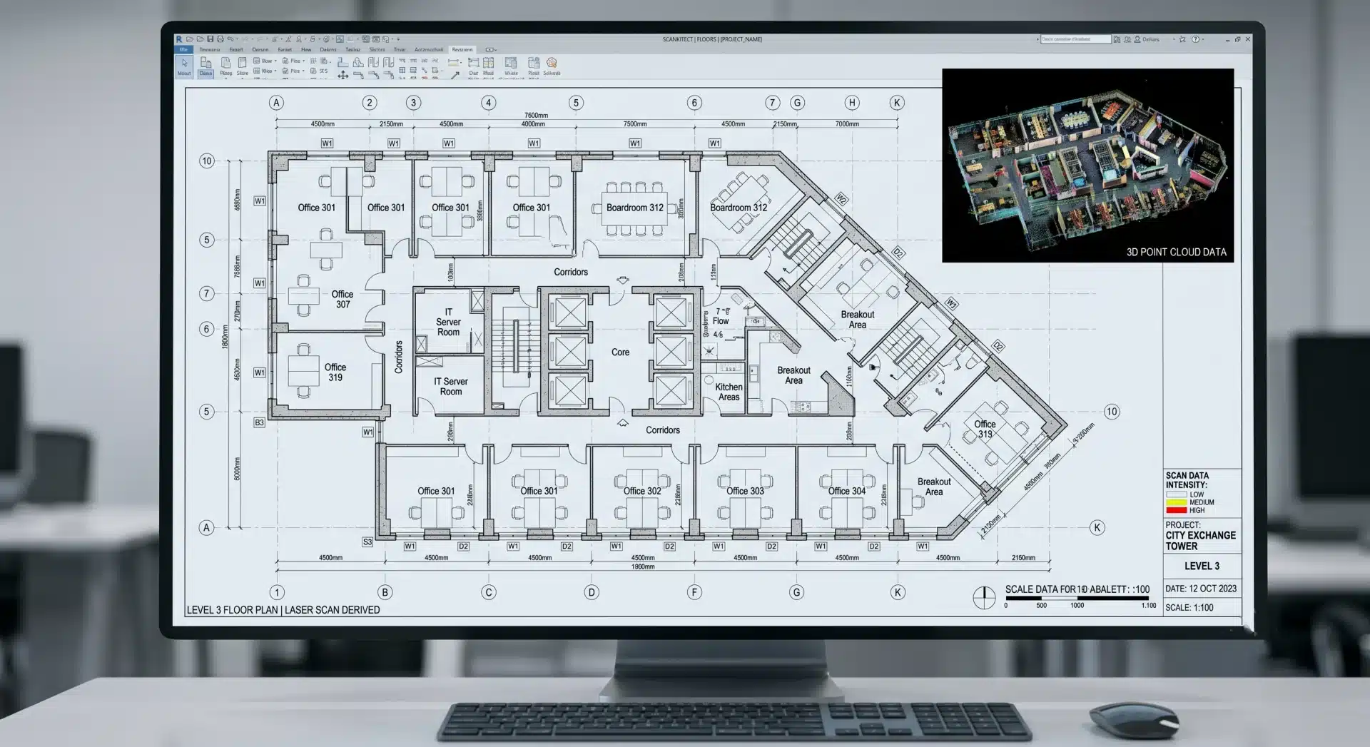
The result is a dense point cloud. A three-dimensional map of the space accurate to ±1–3mm across the entire floor plate, not just the spots someone happened to measure.
For a 2,000 sqm commercial building, that means hundreds of millions of verified data points rather than a few hundred manual measurements. The difference in downstream confidence is significant.
The Workflow: From Site to Floor Plan
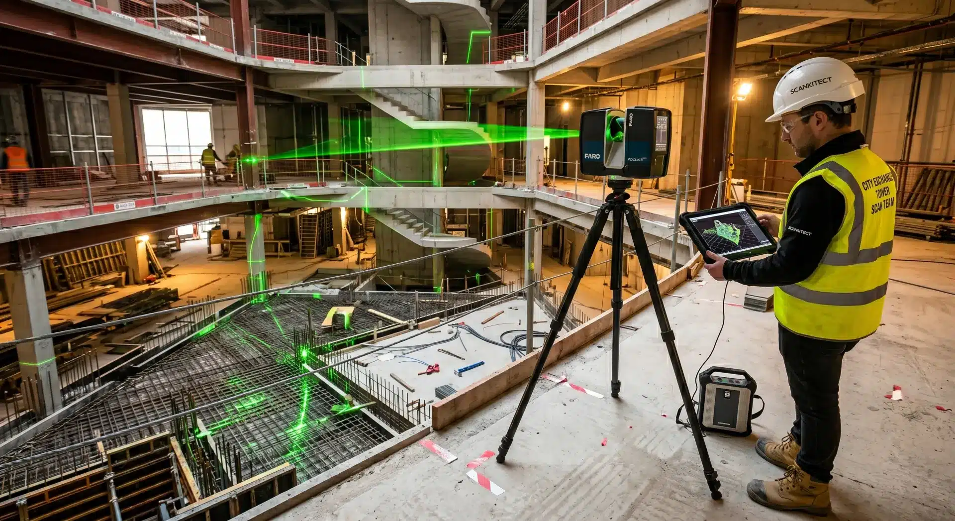
Step 1: Site Scanning
An Avian scanning technician attends the site with a high-accuracy LiDAR scanner. Interior spaces, stairwells, plant rooms, roof voids, and external façades can all be captured. For a typical commercial building of 3,000–5,000 sqm, scanning takes 1–2 days on site, compared to 4–7 days for traditional manual survey methods on buildings of similar complexity.
Multiple scanner positions are registered into a single unified point cloud, with each scan overlapping the next to ensure complete coverage and eliminate shadow zones.
Step 2: Point Cloud Processing
Raw scan data is cleaned, registered, and quality-checked. This stage removes noise, aligns all scan positions to a common coordinate system, and produces a verified point cloud ready for modelling.
Step 3: Floor Plan Drafting
The point cloud is imported into CAD or BIM software (Revit, AutoCAD, Civil 3D) and traced to produce dimensionally accurate floor plans. Walls, columns, openings, stairs, and service zones are all extracted from the scan data rather than interpreted from field notes.
Deliverables typically include 2D floor plans at 1:50 or 1:100 scale, with all critical dimensions annotated.
Step 4: Quality Review and Delivery
Plans are reviewed against the point cloud before delivery to confirm accuracy. Final files are provided in your preferred format (DWG, PDF, RVT, or IFC) ready to drop straight into your design, construction, or FM workflow.
Speed Comparison: Laser Scanning vs Traditional Survey
|
Method |
Site Time (3,000 sqm) |
Plan Production |
Accuracy |
Risk of Error |
|
Manual measurement |
4–7 days |
3–5 days |
±10–30mm |
High (cumulative) |
|
3D laser scanning |
1–2 days |
1–3 days |
±1–3mm |
Very low |
The time saving is real, but for most Australian project teams, the accuracy and completeness of the scan data is the more compelling reason to make the switch.
Deliverables You Can Expect
3D laser scanning floor plans typically come with a range of outputs depending on your project brief:
- Dimensioned 2D floor plans (single level or multi-storey)
- Reflected ceiling plans
- Roof plans and external footprints
- Section cuts through any part of the building
- Elevation drawings
- Point cloud files (E57, RCP) for in-house BIM teams
- Revit models for scan-to-BIM workflows
- Area schedules and room data
The deliverable set is defined upfront in the project brief, so there are no surprises at handover.
Use Cases Across Australian Industries
Renovation and refurbishment
Before a fitout or structural alteration, you need to know exactly what you’re working with, particularly in older buildings where original drawings may be inaccurate or missing entirely.
Construction compliance and as-built documentation
This is growing in importance, particularly on government and infrastructure projects where ISO 19650 and BIM requirements are increasingly specified. 3D scanning for construction teams provides a verifiable record of what was built, not what was planned.
Heritage and adaptive reuse
Complex geometry, curved walls, and irregular structures that would take weeks to manually document are captured completely in a day or two.
Property development and due diligence
These teams use 3D laser scanning floor plans to verify existing Net Lettable Area (NLA) calculations, identify discrepancies between title plans and physical conditions, and provide accurate inputs for design feasibility.
Facilities management
Facilities management teams use floor plans derived from scan data as the foundation for maintenance planning, space management, and capital works programs; particularly in large commercial portfolios where existing documentation is patchy.
What Makes Avian Different
Avian operates across Melbourne, Sydney, and Brisbane with a team of AEC professionals and registered land surveyors who understand how scan data needs to be translated into usable documentation.
Unlike services that provide a point cloud and leave you to figure out the rest, Avian delivers complete, project-ready floor plans and BIM models. Scanning, processing, and drafting are handled in-house, which means tighter quality control, faster turnaround, and a single point of accountability for your project.
Scanning costs for a standard commercial site run from $1,600–$2,200 for a scanning technician day, with plan production quoted per project based on scope and deliverables set.
Ready to Replace Manual Measuring?
Does your next project involve an existing building?
Whether it’s a fitout, heritage restoration, infrastructure upgrade, or asset documentation, choose Avian for 3D laser scanning floor plans.
We’ll help your team save time, reduce coordination risk, and give you a reliable digital record from day one.
Talk to the Avian team on 1300 081 115.