If you’re working on an AEC project that needs accurate spatial data, you have two main scanning options: send a drone up, or set up a laser scanner on the ground. Both produce point clouds. Both feed into CAD drawings, BIM models and digital twins. But they capture very different things, at very different levels of detail, and they excel in very different situations. Picking the wrong one costs time and money. Picking the right one, or combining both, gives your team data they can trust from day one.
Here’s how to understand how each method works, what it measures, how accurate it is, and when you should use one, the other, or both.
Table of Contents
Pricing packages to suit your business
Plans with inclusions for Drone Inspection, Land Surveying, 3D Laser Scanning, Drone Photography & Videography. Get custom quote for your specific requirement.
Reality capture is the process of collecting precise spatial data from a physical site and converting it into a digital format that AEC teams can work with. In practice, that means producing point clouds, 3D models, orthomosaic maps or BIM-ready deliverables that give architects, engineers and contractors an accurate picture of existing conditions.
The two dominant scanning approaches are aerial drone scanning (UAV-mounted LiDAR or photogrammetry) and ground-based laser scanning (terrestrial LiDAR on tripods or handheld devices). Each captures different data at different levels of detail, and the best choice depends on what you are scanning, the accuracy you need and the conditions on site.
What Is Aerial Drone Scanning?
Aerial drone scanning uses unmanned aerial vehicles (UAVs) to capture spatial data from above. There are two main capture methods:
Drone LiDAR
A UAV-mounted laser scanner emits pulses that measure distances to the ground and objects below. Unlike photogrammetry, drone LiDAR can penetrate vegetation canopy to capture bare-earth terrain data. Modern payloads like the DJI Zenmuse L3 capture up to 2 million points per second with a range of 950m.
Drone Photogrammetry
A high-resolution camera captures overlapping aerial photographs, which are then processed by photogrammetry software to reconstruct the scene as a 3D model, point cloud or orthomosaic map. This method produces visually rich, photorealistic outputs and is the more affordable of the two drone capture methods.
What Does Drone Scanning Measure?
Drone scanning measures:
Topography and terrain
Roof surfaces
Building facades (from a distance)
Large-area site features
Vegetation canopy and bare-earth data beneath it (LiDAR only)
Stockpile volumes for earthworks and materials management, and
Corridor mapping for roads, rail and pipelines.
Accuracy
Drone photogrammetry delivers horizontal accuracy down to 1cm, though vertical accuracy is typically two to three times less precise. Drone LiDAR achieves horizontal and vertical accuracy down to 2cm. Both methods reach centimetre-level results when combined with ground control points (GCPs) or RTK positioning.
What Are GCPs and Why Do They Matter?
Ground control points are precisely surveyed reference markers placed on the ground before a drone flight. They’re typically high-contrast checkerboard-patterned targets that are clearly visible in aerial imagery. Each GCP is measured using RTK GPS to establish its exact coordinates. During processing, the software aligns the aerial data to these known positions, correcting for GPS drift and ensuring the final map or model is accurately georeferenced. Without GCPs (or RTK correction), drone data can drift by metres. With them, accuracy tightens to centimetre level.
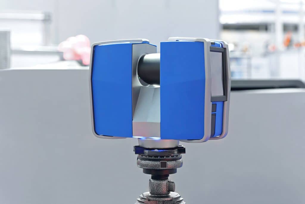
What Is Ground-Based Laser Scanning?
Ground-based laser scanning, also called terrestrial laser scanning (TLS), captures spatial data from ground level using LiDAR scanners positioned within or around a structure. The term “terrestrial” simply distinguishes it from aerial (drone or aircraft-mounted) scanning. Where drones excel at quickly covering large exterior areas, terrestrial scanners are built for the detail work: interiors, tight spaces, and close-range facades where every millimetre counts.
Scanner Types
Terrestrial static scanners (tripod-mounted) deliver the highest accuracy.
Mobile and handheld scanners (SLAM-based) are faster to deploy and ideal for tight spaces, but typically deliver lower accuracy than static scanners
Total stations measure individual points with very high precision and are used to establish survey control networks that tie scan data to real-world coordinates
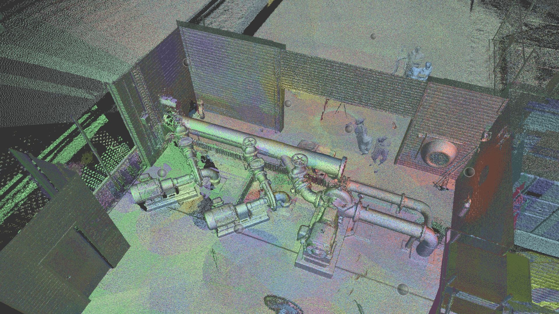
What Does Terrestrial Scanning Measure?
Building interiors, structural elements (columns, beams, slabs), MEP systems (pipes, ducts, conduit), facades at close range, architectural details, industrial plant, confined spaces and ceiling details. If it is inside a building or within line-of-sight from ground level, terrestrial scanning captures it.
Accuracy and Coverage: The Numbers
Terrestrial Scanner Accuracy
2-4mm accuracy across surfaces (Leica RTC360)[4]
Individual point accuracy to sub-millimetre level when combined with total station survey control
For deformation monitoring applications, repeat scans can detect structural movement at sub-millimetre resolution by comparing point clouds over time
As-built documentation error rates: less than 2% with laser scanning, compared to 12-15% with traditional manual methods
Terrestrial Scanner Coverage
Each scan position captures a sphere of data around the scanner
A typical building survey requires multiple scan positions per room or space
Large buildings can require 50-200+ scan positions in a single day, depending on complexity and access
Aerial Drone Scanning vs Ground-Based Laser Scanning: Head-to-Head Comparison
The choice between drone and ground-based scanning is not about which method is better overall. It is about which method fits the project. Drones cover large exterior areas quickly and provide site context that would take days to capture from ground level. Terrestrial scanners capture interiors in extraordinary detail, including MEP systems and structural elements that a drone will never see. Covering a 10-hectare site from ground level is slow and impractical. Scanning a mechanical room from 100m in the air is impossible.
Aerial Drone Scanning
Ground-Based Laser Scanning
Combined Approach
Best for
Topography, terrain, roofs, large sites, corridors, stockpiles
Dense point clouds, 2D CAD, 3D BIM models, digital twins
All of the above, unified in a single coordinate system
Our Project Portfolio
A few of our past projects from our years of experience of working with 100+ clients in AEC Industry carrying out 3D Laser Scanning, modelling, volumetric calculations, aerial inspections, mapping & contour surveys, aerial land surveying, photomontage and much more.
Combining Drone and Ground-Based Scanning: The Best of Both
For many AEC projects, the answer isn’t one or the other. It’s both. Combining aerial and terrestrial scanning in a single mobilisation gives you complete site documentation: exterior context from the drone and interior detail from the ground scanner, unified in one coordinate system.
Several photogrammetry software platforms now support importing both airborne and terrestrial LiDAR into the same project, making it straightforward to merge datasets captured with different equipment and at different times.
This combined approach is particularly valuable for:
Renovation projects where you need both the building envelope (roof, facades, site context) and the interior layout (floor plans, MEP, structural)
Large industrial or infrastructure sites where exterior terrain data needs to be integrated with interior plant documentation
Heritage projects where the exterior form and the interior fabric both need to be recorded to conservation standards
Construction monitoring where drone flyovers track overall progress and terrestrial scans verify specific structural and MEP milestones
The key to a successful combined survey is survey control. By establishing a shared coordinate system using total station or GNSS control points before either the drone or the ground scanner starts capturing, the aerial and terrestrial datasets can be registered together seamlessly. The result is a single, unified model of the entire site that every stakeholder can work from, regardless of which method captured which data.
Get the Right Scanning Approach for Your Project With Avian
Avian Australia delivers aerial drone scanning, terrestrial laser scanning and combined survey services across commercial, infrastructure and heritage projects. Whether you need a drone flyover for a large site, a full interior scan-to-BIM for a renovation, or a combined approach that captures both, our team will recommend the right approach for your site.
Contact Avian today to discuss your next scanning project.
Have a question for us ?
Our team is eagerly waiting to know about your queries. Please call us at the number below during business hours and our team will help you out.