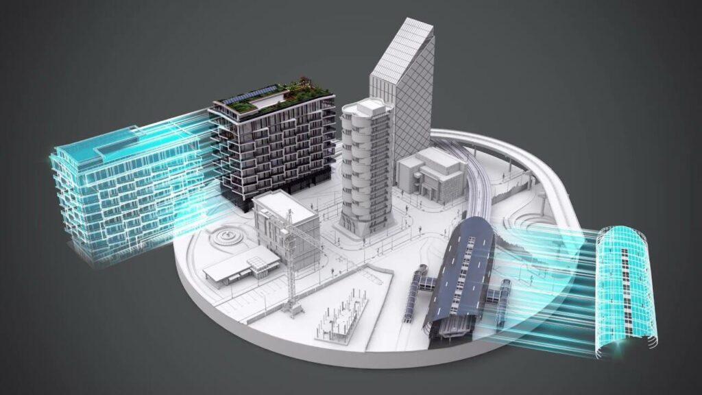
A BIM model tells you what was planned. An as-built survey tells you what was built. A digital twin goes further: it tells you what’s happening right now, and what’s likely to happen next. By layering real-time sensor data onto a verified 3D model, digital twins provide construction and operations teams with a live, evolving replica of the physical structure they manage.
The foundation for all of this is accurate 3D scan data. Avian Australia has delivered 200+ AEC projects using 3D laser scanning to create the spatial backbone that digital twins depend on, and the results are consistent: fewer clashes, less rework and faster decisions at every phase.
Table of Contents
Pricing packages to suit your business
Plans with inclusions for Drone Inspection, Land Surveying, 3D Laser Scanning, Drone Photography & Videography. Get custom quote for your specific requirement.
What Is a Digital Twin, and How Does 3D Scan Data Connect?
A digital twin is a virtual replica of a physical asset that updates in real time. Unlike a static 3D model, it pulls live data from sensors, IoT devices, and building management systems to mirror what is happening in the structure in real time.
3D scan data is the spatial information captured by laser scanners or LiDAR devices. These scanners fire millions of measurement points per second, producing a dense point cloud that accurately represents every visible surface to within ±1-2mm.
The point cloud defines the digital twin’s shape. It provides the verified as-built geometry and the twin platform layers’ operational data on top: energy consumption, temperature, equipment performance, and occupancy. Without accurate scan data, the twin is working from assumptions.
What Is a Digital Twin in Detail?
Digital twins exist across a spectrum of complexity:
Component twins track individual building systems (a chiller unit, a fire suppression system, a lift)
Asset twins cover complete structures or standalone assets (an entire HVAC system, a façade assembly)
System twins connect multiple assets to model how they interact (the full MEP network of a commercial building)
Process twins simulate workflows and operational sequences (construction staging, maintenance scheduling)
What separates a digital twin from a regular 3D model is the data flowing through it. A BIM model is a snapshot, while a digital twin is a living system that updates continuously and supports decisions based on current conditions.
Factors that affect construction time lapse videos
Producing and shooting a time lapse video needs a lot of planning, here are some factors that we look into when deciding the budget for time lapse videos.
1. Project duration
The longer the time lapse video is, the more it is going to cost. This is because time lapse videos need to be captured at regular intervals so the camera must be powered for a longer period of time. Unlike other shorter videos, time lapse videos are captured over a period of time but sped up to make the on-site activities appear to happen in a few seconds.
2. Equipment and resources
Indoor and outdoor time lapse videos need different kinds of shooting equipment, power supply and mounting hardware. You need to identify the initial set-up costs such as HD cameras, tripods, crane arms etc. Plus, depending on how long the cameras need to record can affect if there is adequate positioning or security.
3. Deliverables needed
Time lapse videos usually need a bit of editing and modification. The photos or videos recorded need to be compiled and edited into a video. This usually involves adding the time lapse to an existing edit or production.
Digital Twin vs BIM Model: What Is the Difference?
This is one of the most common questions in AEC, and the short answer is: they’re not competitors: BIM is the foundation; the digital twin is what you build on top of it.
Feature
BIM Model
Digital Twin
Primary purpose
Design and construction planning
Operational monitoring and optimisation
Data type
Static or semi-static (updated at milestones)
Dynamic, real-time (updated via sensors and IoT)
Lifecycle focus
Design through to construction handover
Construction through to operations and decommissioning
Primary users
Architects, engineers, contractors
Facility managers, operations teams, building owners
Update frequency
At project milestones (DD, CD, as-built)
Continuous (seconds to minutes)
Core question
What did we plan and build?
What is happening now and what will happen next?
Scope
Typically a single building or structure
Can span multiple buildings, systems or entire precincts
Our Project Portfolio
A few of our past projects from our years of experience of working with 100+ clients in AEC Industry carrying out 3D Laser Scanning, modelling, volumetric calculations, aerial inspections, mapping & contour surveys, aerial land surveying, photomontage and much more.
Data from BIM services for construction provides the baseline for a digital twin. Think of BIM as the skeleton and the digital twin as the living body around it.
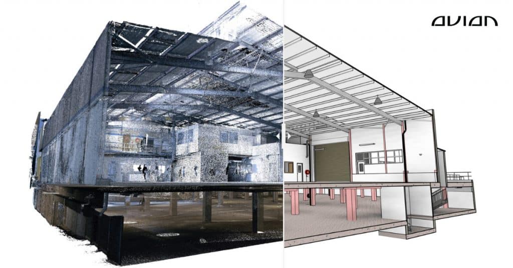
How 3D Laser Scanning Creates the Foundation for Digital Twins
Every digital twin worth trusting starts with accurate spatial data. 3D laser scanning captures it by emitting laser pulses that measure the distance to every visible surface, producing a dense point cloud. This gives the twin its geometric backbone:
As-built conditions captured with ±1-2mm accuracy, so the twin reflects reality from day one
Complex geometry, concealed services and hard-to-access areas documented in a single visit
Data that plugs directly into BIM platforms (Revit, Navisworks) and digital twin software
Understanding the 3D laser scanning cost in Australia upfront helps teams budget for reality capture, typically a small fraction of the total digital twin investment.
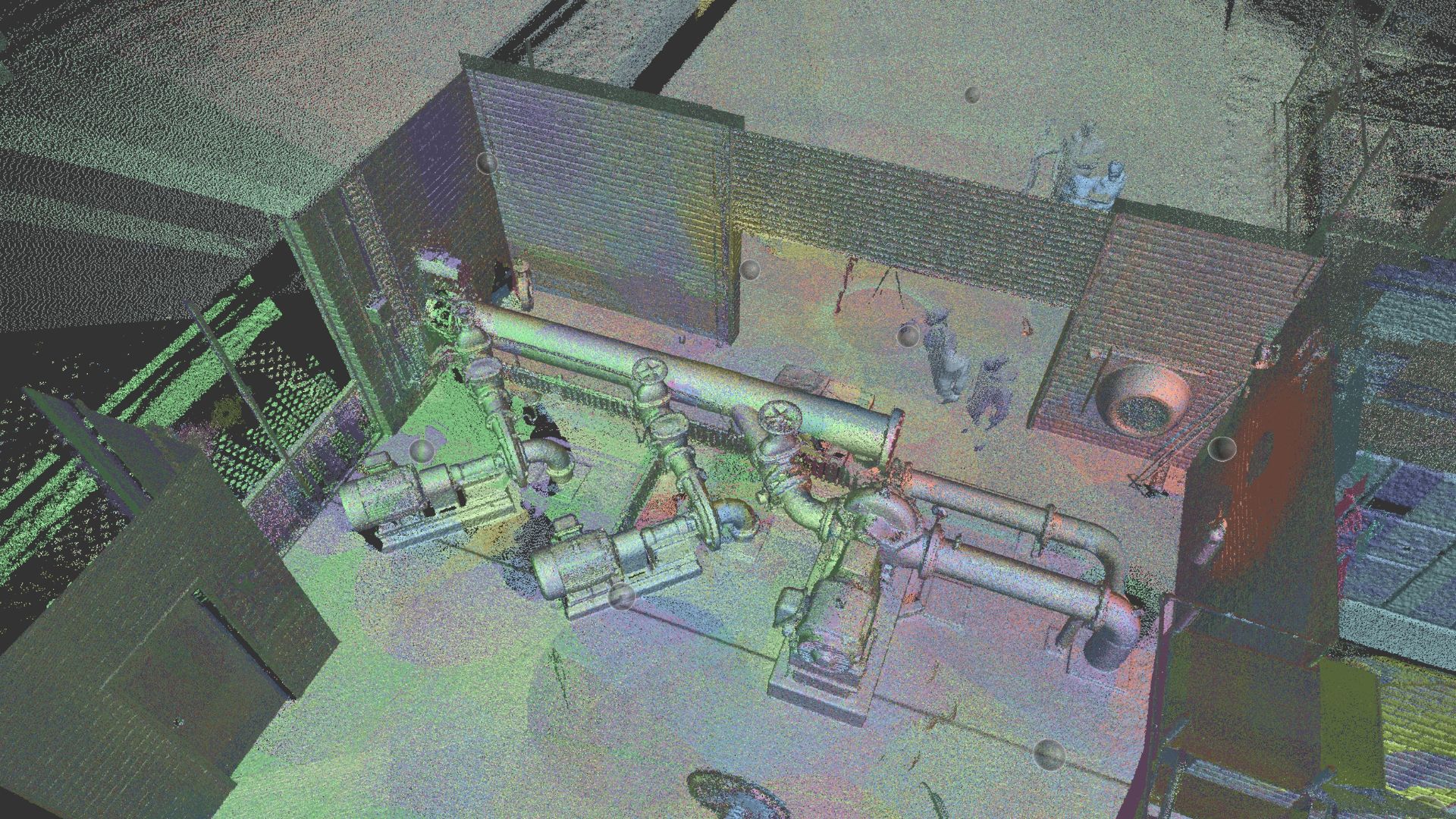
What Is a Point Cloud and How Does It Become a Digital Twin?
A point cloud is the raw output of a 3D laser scan: millions of measurement points, each with X, Y and Z coordinates. Together they form a precise 3D map of the scanned structure. The pipeline from point cloud to digital twin looks like this:
Registration: individual scans are stitched into a single, unified coordinate system
Cleaning: noise, duplicate data and irrelevant points are stripped out
Modelling: the cleaned data is converted into intelligent 3D geometry using best practices laser scan to model workflows, typically producing a Revit BIM model
Enrichment: the model gets layered with material specs, equipment data and maintenance schedules
Integration: IoT sensors and building management systems are connected, turning the static model into a live digital twin
Effective point cloud processing for construction is critical early in this pipeline, as errors at the registration stage compound through every layer of the twin.
Have a custom requirement ?
Get a quick estimate for your specific project requirements with listed inclusions/exclusions.
What Role Does LiDAR Play in Digital Twin Accuracy?
LiDAR (light detection and ranging) is the technology behind most construction-grade digital twins. It fires laser pulses and measures return times to calculate precise distances. Modern scanners like the Leica RTC360 capture up to 2 million data points per second with 2-4mm accuracy, producing colourised 3D point clouds in under two minutes per scan position:
2-4mm measurement accuracy across scanned surfaces, far exceeding what manual tape or disto measurements can achieve consistently across a full site
Comprehensive coverage of every visible surface, including areas that are dangerous or difficult to reach manually
Speed that allows large sites (10,000+ sqm) to be documented in days, not weeks
According to iScano’s industry research, the average error rate for as-built documents produced by traditional manual methods is 12-15%, while laser-scanning-based documentation reduces it to less than 2%. For a digital twin, that difference matters because geometric errors in the base model undermine every prediction built on top of it.
Five Ways Digital Twins Improve Construction Project Outcomes
1. Clash Detection and Design Coordination
Digital twins compare designed conditions against as-built reality in real time, catching clashes before they hit the field.
2. Construction Progress Monitoring
Periodic re-scanning and overlay against the digital twin shows you exactly where the project is tracking versus the plan.
3. Prefabrication and Off-Site Manufacturing
When prefabricated components are manufactured from scan-verified dimensions, they fit the first time.
4. Facility Management and Predictive Maintenance
Once construction is done, the digital twin becomes the operational backbone for building management.
Facility management costs are reduced through optimised maintenance scheduling
Maintenance response times improve with accurate spatial and system data
5. Risk Reduction and Compliance Documentation
A digital twin provides a verified, time-stamped record of as-built conditions that holds up during audits, disputes and handover:
Defects liability disputes reduce when verified scan data backs up the handover record
Permit and approval timelines shorten with coordinated, verifiable documentation
The Process of Building a Construction Digital Twin From 3D Scan Data
Step 1: Project Scoping and Planning
Work out what you need the digital twin to do: asset management, construction monitoring, operational optimisation, or all three. Lock in deliverable formats, integration requirements and scan coverage.
Step 2: 3D Laser Scanning and Data Capture
Deploy LiDAR scanners to capture as-built conditions, establish survey control points and collect supporting photography alongside the point cloud data.
Step 3: Point Cloud Processing and Registration
Individual scans are registered into a unified coordinate system, cleaned and prepared for modelling. Quality checks confirm accuracy before anything moves downstream.
Step 4: Scan-to-BIM Modelling
The processed point cloud is converted into an intelligent 3D BIM model in Revit, including building geometry, structural elements, MEP systems and spatial relationships.
Step 5: Data Enrichment, IoT Integration and Deployment
Operational data gets layered onto the model: equipment specs, maintenance histories and live sensor feeds. The twin is deployed on a cloud platform, with protocols set for periodic re-scanning and data updates to keep it aligned with the physical asset.
Build Your Digital Twin With Avian
Avian Australia delivers end-to-end digital twin services, from 3D laser scanning and point cloud processing through to scan-to-BIM modelling and IoT integration across commercial, infrastructure and heritage projects.
Contact Avian today to discuss your next digital twin project.
Have a question for us ?
Our team is eagerly waiting to know about your queries. Please call us at the number below during business hours and our team will help you out.