Our Solutions for Construction

As-Built Documentation

Capture the existing conditions of a site or structure and create accurate “as-built” plans used for design and planning for all project teams and contractors. 

Let’s ensure what’s built matches what was planned with the right site documentation from the start.

Progress Monitoring

Run scans throughout the build process to track progress, identify deviations from specifications, and ensure quality standards are met. This helps prevent costly delays, rework and supports more effective project management.

Quality Control and Verification

Compare 3D scans against BIM or CAD models to verify construction elements are installed correctly and within tolerance, detect any discrepancies, reduce rework and ensure high-quality outcomes.

Clash Detection and Coordination

In complex projects involving multiple systems (e.g., HVAC, electrical, plumbing), 3D scanning for construction can help identify spatial conflicts between components before installation, enabling teams to resolve issues proactively. Contractors work is checked to ensure specifications have been met avoiding costs or delays

Site Planning and Safety

Use 3D scan data to assess site topography, clearances, and access routes. This can improve site planning and enhance safety and project efficiency by reducing the need for delays or manual measurements in hazardous areas.

Renovation and Retrofit Projects

For older buildings or structures without accurate documentation, 3D laser scanning for construction provides essential measurements and geometry, forming a reliable foundation for design, renovation or expansion.

Post-Construction and Handover

Post-build scans provide a comprehensive digital record of the finished structure, supporting effective facility management, maintenance planning, and future upgrades. BIM models are used to document contractor history and maintenance schedules. 

3D Scanning Delivers Accuracy You Won’t Find Anywhere Else

Our 3D scanning for construction project management provides highly accurate documentation of your site, enabling precise planning, layout verification, and on-site coordination. Using state-of-the-art laser scanning and surveying technology, we capture detailed spatial data for both structural and architectural elements across commercial buildings, infrastructure works, and active construction sites.


3D laser scanning for construction offers fast, precise recording of real-world conditions, delivering exact measurements and geometry to support construction workflows, reduce errors, and keep projects on track. When combined with our 3D scanning and laser scanning for reverse engineering, this ensures smooth project delivery from design and conception to build and completion.


At Avian, we combine advanced laser scanning, surveying, and geospatial tools to produce millimetre-accurate as-built data, giving construction teams the confidence to build, inspect, and hand over with clarity and efficiency.

Architecture_Effectively-measure-3_Avian@2x
Architecture_Effectively-measure-2_Avian@2x
Architecture_Effectively-measure-1_Avian@2x
pipework point cloud processing using autodesk software

Scan to BIM

Group 9590@2x

Scan to Plan

Screen Shot 2020-06-15 at 8.34.06 pm

Scan to Model

Start designing sooner with direct Software Integration

Seamlessly integrate with industry-standard software such as Autodesk Revit, Civil 3D, AutoCAD, Archicad, Solidworks, Microstation, Rhino and Bentley Systems.

Experience immediate integration of scan data for modelling and design applications.

Share and collaborate laser scan data and 3D models with teams, stakeholders and clients via our secure web-based applications.

Architects_Software-Integration_Avian@1.2x

The Benefits of 3D Laser Scanning for Construction

Increased Speed to Delivery

3D scanning captures comprehensive site data in a fraction of the time of manual methods, meaning quicker design verification, streamlined workflows, and the ability to meet tight deadlines, helping you deliver projects sooner.

Competitive Advantage in Bidding

High-quality visualisations and accurate models can help win more jobs – firms offering 3D scanning capabilities stand out in tenders by demonstrating precision, efficiency, and innovation.

Reduced Rework and Cost Overruns

Accurate as-built data helps catch errors early and ensures everything is built according to plan. This reduces costly rework, change orders, and material waste.

Better Coordination and Fewer Delays

3D scan data provides a single source of truth. It helps identify clashes and design issues early, reducing delays and ensuring smoother coordination across teams and trades.

Improved On-Site Safety

Limit the need for your workers to access dangerous or hard-to-reach areas and reduce risk, enhance compliance, and help maintain a strong safety record on-site.

Construction_Drone-Propellers_Avian@1.2x
Dedicated Services from Leading Land Surveyors in Melbourne

Why Choose Our 3D Scanning for Construction Management Projects?

Avian is a leading Australian 3D laser scanning company trusted by construction firms nationwide. We currently offer 3D scanning and laser scanning services in Brisbane, Sydney and Melbourne. We also offer architectural 3d scanning services.

We’ve partnered with a diverse range of construction companies on large-scale commercial and infrastructure projects, delivering the precise site data needed to deliver accurate builds on tight timelines.

By combining cutting-edge construction 3D scanning technology, ongoing team training, and robust quality assurance processes, we ensure your construction team has reliable, high-detail data required for successful execution from start to finish.

Clearer Stakeholder Communication

Help your contractors, project managers, and clients visualise site conditions and construction progress with confidence and clarity.

Accelerated Approvals and Planning

Streamline design validation, compliance checks, and early-stage planning with faster approvals and better-informed decision-making.

Stronger Client Relationships

Exceed expectations and win repeat business with visual and technical outputs demonstrating quality and professionalism.

Our Construction 3D Scanning Projects

100+ CLIENTS

Kevington

Renders

Hunt Crescent

Visualisations

3D Revit models, 3d laser scanning survey

3D Models

Contact the team at Avian today to discuss your projects

3D Scanning for Construction FAQs

3D scanning captures precise as-built conditions of a construction site at various stages. It supports layout verification, progress tracking, and quality control. The resulting data helps project teams validate installations, monitor changes, and reduce the risk of errors or rework.

3D laser scanning for construction is valuable for a wide range of projects, including commercial buildings, infrastructure, industrial facilities, and fit-outs. It’s especially useful for renovations, retrofits, and complex builds where accuracy and coordination are critical to project success.

Most site scans can be completed within a single day, depending on the size and access conditions. Once data is collected, it typically takes 1–2 weeks to process and deliver outputs such as point clouds, CAD drawings, or BIM models.

Yes. By comparing scan data with design models (such as BIM), 3D scanning can reveal misalignments, incomplete installations, or deviations from earlier plans, allowing teams to take corrective action before issues escalate or cause delays.

3D scanning provides full spatial documentation in a fraction of the time, reducing manual errors and improving site safety. It captures millions of data points quickly, delivering a comprehensive, accurate view of the site that manual measurements can’t match – saving time, cost, and effort.

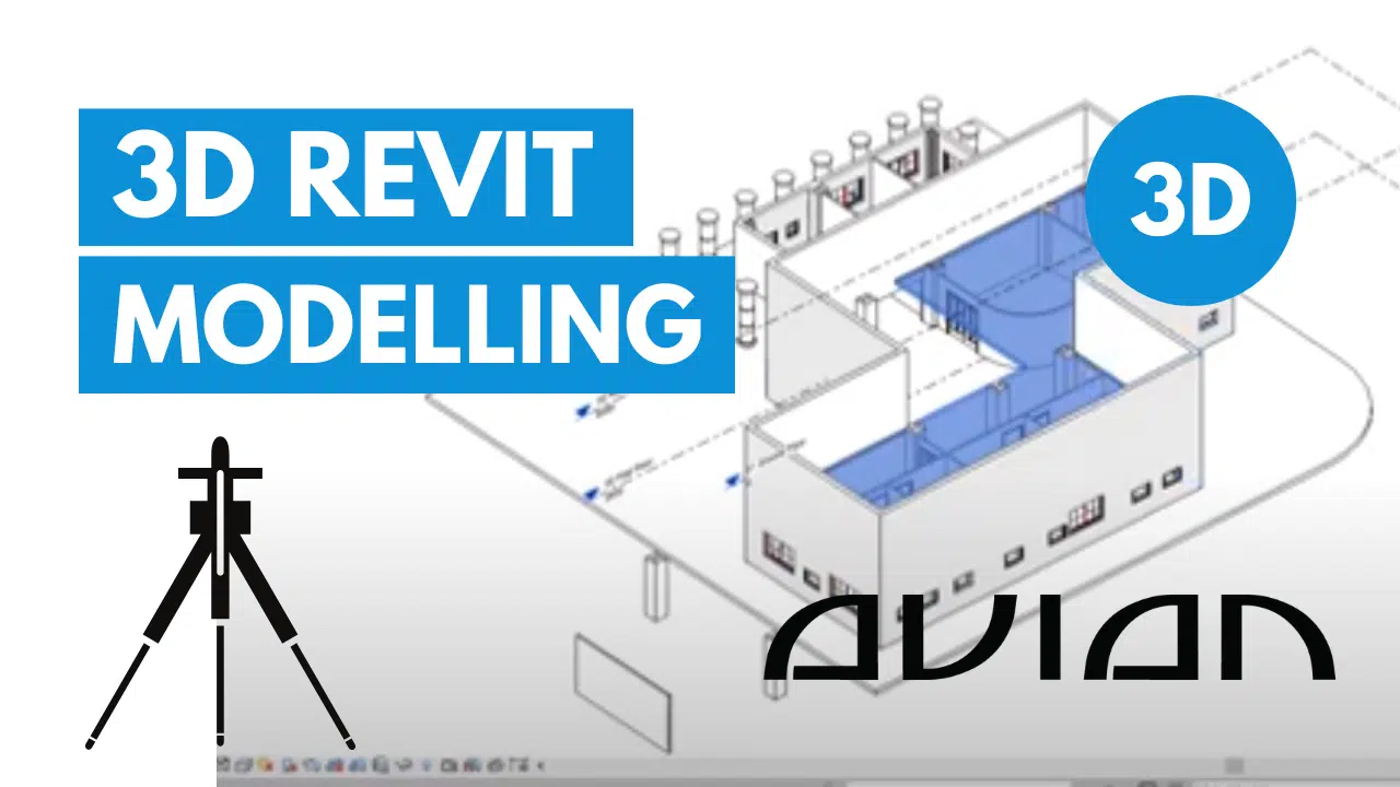
We deliver scan data in construction-ready formats, including point clouds (E57, RCP), 2D drawings (DWG), and 3D BIM models (Revit, IFC). These files are compatible with construction software, allowing your team to easily use the data for planning, clash detection, layout verification, or handover documentation.