If you’ve ever walked through a construction site, toured a historic building, or even stood at the edge of a cliff face, you’ll know one thing for sure: details matter. The tilt of a wall, the curve of a staircase, the exact slope of a road can mean the difference between a successful project and a costly mistake.
That’s where point cloud surveys come in. By capturing millions of precise data points and stitching them together into a 3D model, this technology gives architects, engineers, and surveyors a crystal-clear view of reality. Think of it as a digital twin of the world around you: accurate to the millimetre, rich with detail, and ready to be used across countless industries.
We’ll take a closer look at the many point cloud benefits, what is a point cloud survey, and its top 10 uses. From restoring centuries-old cathedrals to planning tomorrow’s infrastructure, you’ll see why this tool is fast becoming the gold standard for precision.
Table of Contents
Pricing packages to suit your business
Plans with inclusions for Drone Inspection, Land Surveying, 3D Laser Scanning, Drone Photography & Videography. Get custom quote for your specific requirement.
Our Pricing Plans
What Is Point Cloud Technology?
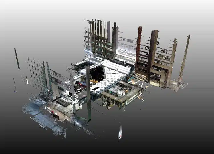
Point cloud technology is the process of using specialised laser scanners or photogrammetry to capture millions (or even billions) of spatial data points. These points represent the precise location of surfaces, objects, or environments in three-dimensional space. When viewed together, they form what’s known as a “point cloud,” essentially a digital snapshot of reality in extreme detail.
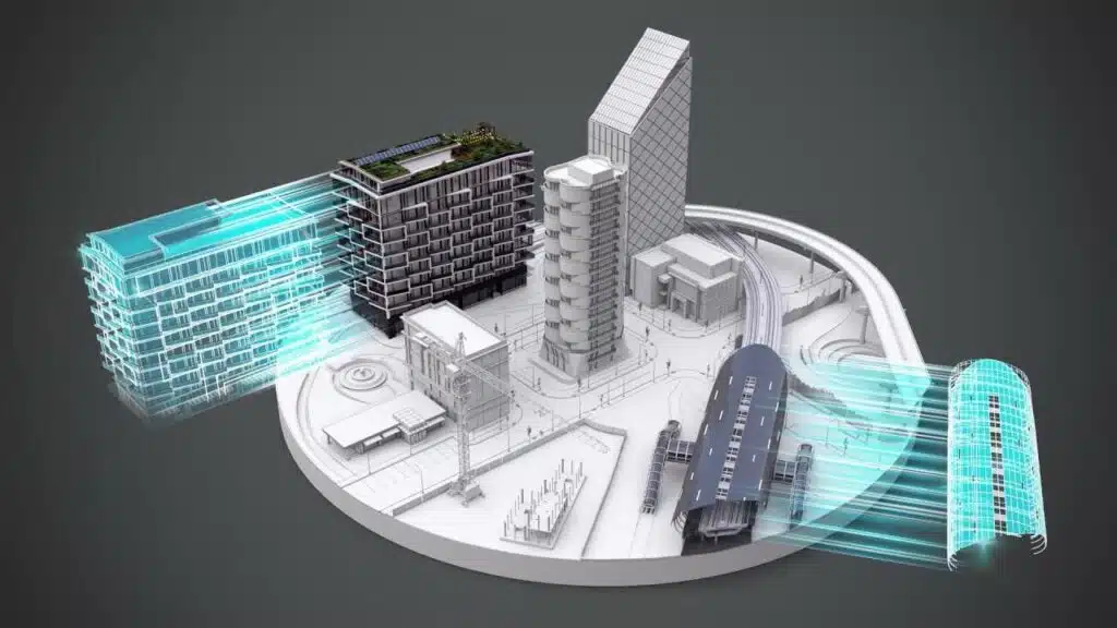
This technology provides engineers, architects, and surveyors with a powerful way to document environments exactly as they exist, creating a digital twin that can be analysed, measured, and modelled. Instead of relying on traditional two-dimensional drawings or tape measures, professionals now have access to 3D models accurate down to millimetres.
What Is a Point Cloud Survey?
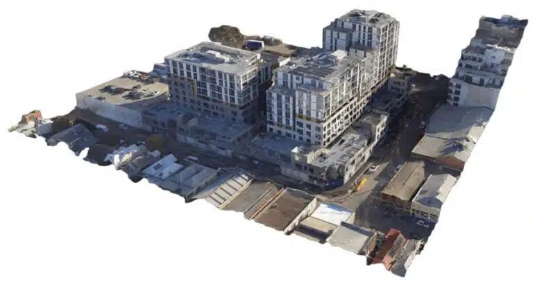
A point cloud survey is the practical application of this technology. Using advanced scanning equipment, surveyors capture highly detailed measurements of buildings, landscapes, or industrial facilities. The data is then processed into a 3D point cloud model, which can be converted into CAD or BIM software for use in design, analysis, or monitoring.
The result is a complete and precise representation of a site or structure that helps project teams make smarter decisions from the outset. Unlike traditional surveys, a point cloud survey can cover vast areas quickly, reducing manual labour while dramatically improving accuracy.
What Equipment Is Used in Point Cloud Surveys?
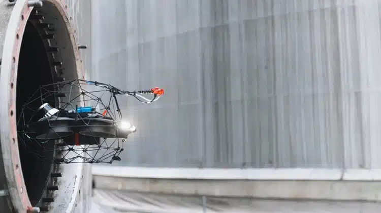
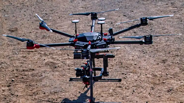
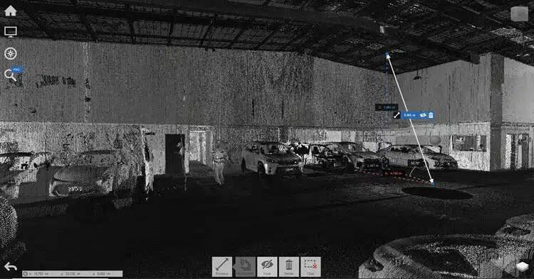
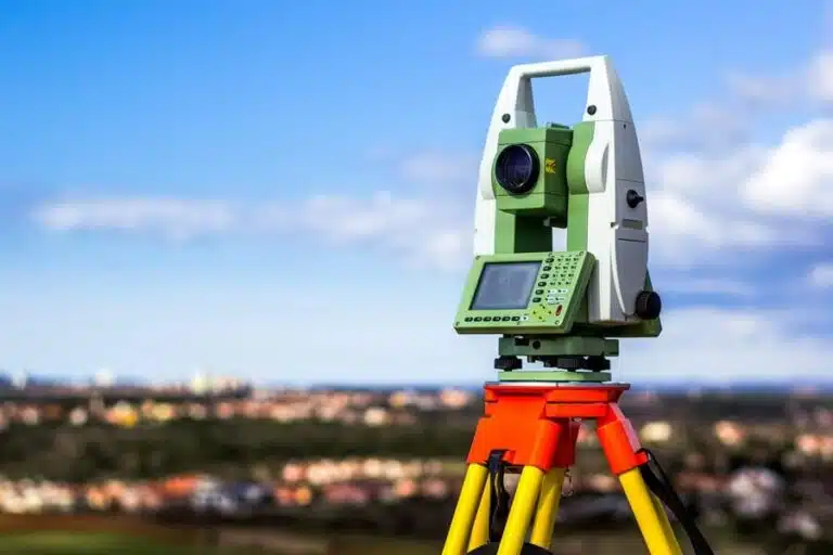
Point cloud surveys rely on advanced technology to capture and process spatial data. The most important of these tools are 3D laser scanners, which use LiDAR (Light Detection and Ranging) to measure millions of points in space with millimetre-level accuracy. When surveyors refer to 3D laser scanning services, they’re talking about the professional process of deploying this equipment on-site and delivering the results as usable datasets or models.
The raw output of a laser scan is a point cloud: a dense collection of 3D coordinates that replicates the exact dimensions and geometry of a space. From there, point cloud technology and specialist software transform this data into detailed models that can be used for design, monitoring, or analysis.
Alongside laser scanners, surveyors also make use of:
- Total Stations: Often combined with laser scanning to anchor the data to precise geodetic coordinates.
- Drones and UAVs: Equipped with LiDAR or photogrammetry cameras, drones allow for quick, safe capture of large or difficult-to-access areas.
- Specialist Software: Programs like Revit, AutoCAD, or Cyclone Register process raw point cloud data into BIM or CAD models, enabling everything from clash detection to structural analysis.
What Are the Top 10 Uses for Point Cloud Surveys?
The true value of a point cloud survey lies in how its data can be applied. Here are ten of the most impactful ways industries are putting this technology to use.
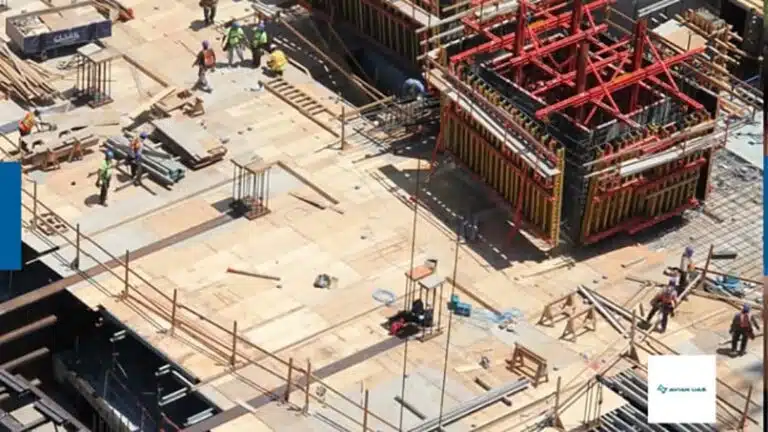
1. Designing New Construction Projects
Point cloud surveys are invaluable during the early stages of construction. By providing a detailed 3D model of the existing site conditions, architects and engineers can design with complete confidence. This minimises the risk of design clashes and ensures projects get off the ground with a strong foundation of accurate data.
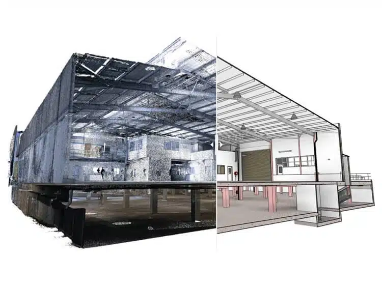
2. Creating As-Built Documentation
Traditional “as-built” drawings often fail to capture the exact details of a finished project. Point cloud surveys, however, create an ultra-precise record of how a building or structure exists in reality. This digital documentation can be referenced throughout the building’s lifecycle, ensuring future renovations or repairs are based on reliable information.
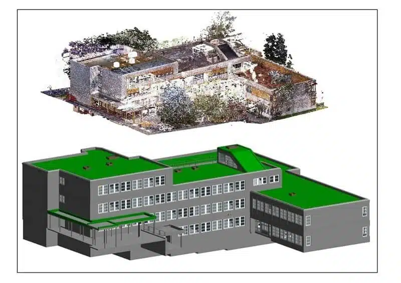
3. Supporting Building Information Modelling (BIM)
BIM relies on accurate data to function effectively. A point cloud survey integrates seamlessly into BIM workflows, providing detailed inputs for clash detection, design updates, and facilities management. This reduces costly errors and enhances collaboration across project teams.
4. Monitoring Structural Deformation
Bridges, tunnels, and high-rise buildings are subject to wear and tear over time. Point cloud surveys allow engineers to monitor structural shifts or deformations by comparing datasets captured at different intervals. This proactive approach helps detect problems early, improving safety and reducing maintenance costs.
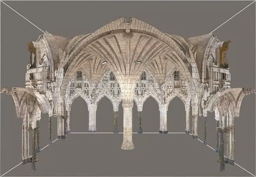
5. Heritage and Historic Building Preservation
Preserving heritage sites requires meticulous accuracy. Point cloud surveys provide a non-invasive way to capture every detail of historic buildings, from ornate carvings to complex roof structures. This ensures accurate digital records are available for restoration, repair, or academic research without risking damage to the site.
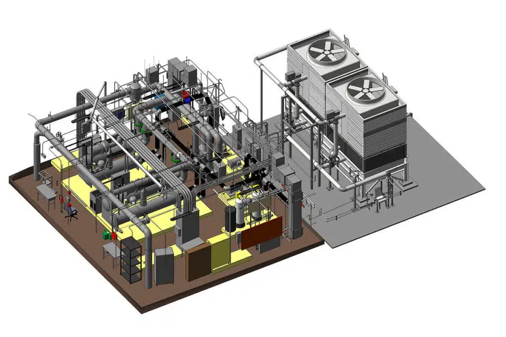
6. Industrial Facility Management
Factories, plants, and refineries often contain complex layouts with machinery, pipes, and safety systems. Point cloud surveys create precise digital twins of these facilities, allowing for easier planning of upgrades, retrofits, or health and safety assessments. This is particularly valuable for sites where downtime is costly.
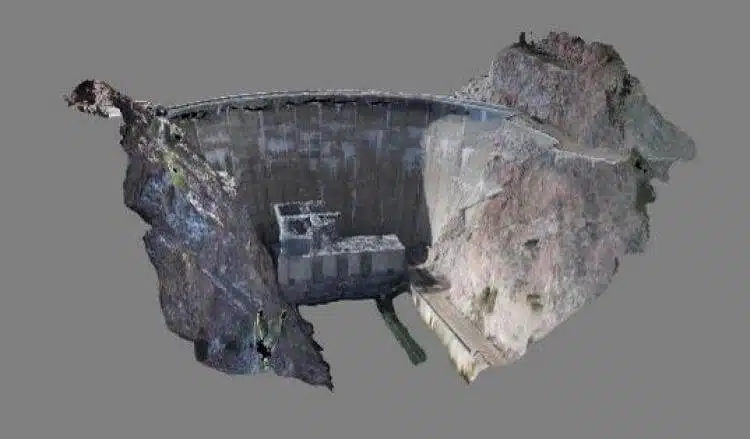
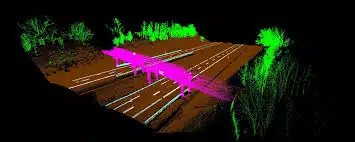
7. Infrastructure Development
Highways, railways, and airports require precise planning and monitoring. Point cloud surveys help map out these large-scale projects quickly and accurately, supporting alignment studies, earthworks calculations, and progress tracking.
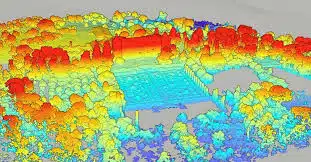
8. Environmental and Climate Monitoring
Beyond construction, point cloud surveys play a critical role in monitoring natural landscapes. From coastal erosion to glacial retreat, this technology provides scientists with accurate datasets to track environmental changes over time. This information is vital for developing sustainable strategies to combat climate change.
9. Renovation and Refurbishment Planning
Whether modernising office spaces or repurposing industrial warehouses, point cloud surveys ensure that design plans are based on real-world conditions. This minimises surprises during construction and provides clear insights into where adjustments are necessary.
10. Virtual Reality and Digital Twins
Point cloud data can be transformed into immersive 3D environments, enabling virtual reality walkthroughs or fully-fledged digital twins. These tools are increasingly being used in design presentations, facilities management, and even health and safety training.
What Types of Projects Require Point Cloud Laser Scanning Surveys?
Beyond individual tasks, certain sectors rely heavily on point cloud data to deliver precision and efficiency, such as:
Heritage and Historic Building Surveys
Historic buildings are often fragile, making physical inspection challenging. Point cloud surveys offer a safe, non-invasive method for capturing details, ensuring architects and conservationists can plan restorations with millimetre-level accuracy.
Commercial Properties
Office towers, shopping centres, and mixed-use developments benefit greatly from point cloud data. Surveys streamline refurbishment projects and provide reliable models for property managers overseeing complex facilities.
Construction and Infrastructure Projects
Large infrastructure works such as railways, roads, and bridges are perfect candidates for revolutionising construction with point clouds. This technology delivers precise alignment data and progress monitoring, ensuring efficiency on a grand scale.
Industrial Facilities and Plant Surveys
Industrial plants present unique challenges with their dense networks of pipes, conveyors, and machinery. Point cloud surveys create comprehensive models that assist with retrofitting, expansions, and health and safety compliance.
Monitoring Climate Change and Natural Sites
Environmental scientists use point cloud surveys to track erosion, deforestation, and coastal changes. The precision of the data provides a robust basis for developing strategies that mitigate the effects of climate change.
Shaping Tomorrow with Precision
The rise of point cloud surveys is reshaping how we approach design, construction, and environmental monitoring. From safeguarding heritage sites to supporting large infrastructure projects, the benefits are far-reaching. Professionals now have access to data that is more accurate, more detailed, and more versatile than ever before.
Whether you’re adopting 3D scanning for engineering projects or seeking to bring precision into construction and environmental management, the many point cloud benefits are clear. As industries continue to demand greater accuracy and efficiency, the future of surveying is undoubtedly three-dimensional.
Unlock the Power of Precision with Avian
When it comes to planning, designing, or monitoring complex projects, guesswork isn’t an option. Avian’s point cloud surveys capture every detail with millimetre accuracy, turning real-world environments into reliable 3D models. From heritage restoration to large-scale infrastructure, our data gives you the clarity to make confident decisions at every stage.
Ready to see your project in 3D clarity? Partner with Avian and discover how our 3D laser scanning services and survey solutions deliver the insight and accuracy you need to move forward without hesitation.
Have a custom requirement ?
Get a quick estimate for your specific project requirements with listed inclusions/exclusions.
Get a Quote Estimate

