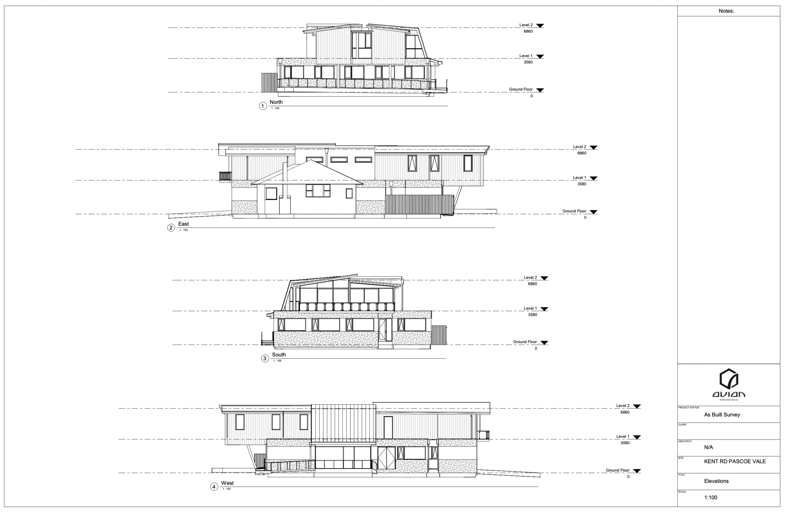
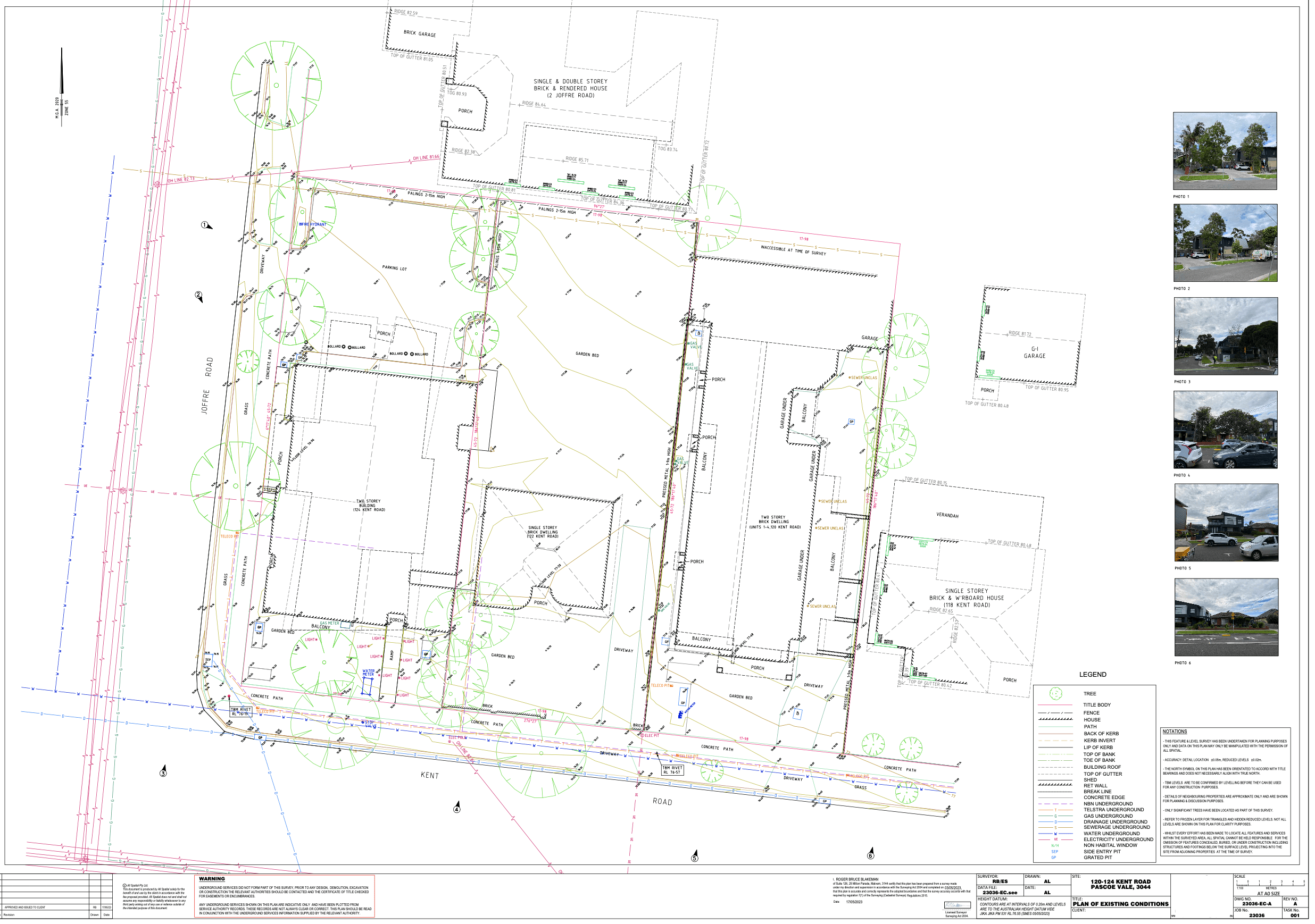
Land Surveying and As-Built Drawings

Avian Australia partners with commercial construction to deliver land surveying and drafting services.

Combining surveying and laser scanning on a retail construction site has its benefits far beyond efficiency and accuracy.

In partnering with construction and building companies, Avian Australia is able to conduct multiple services in the same visit that allows us to deliver a myriad of outcomes to the client resulting in time and cost savings and a reduction in additional delays.

Avian Australia reduces the time required on site by acquiring the necessary data using a combination of surveying and laser scanning technologies to capture a precise digital twin of the subject site and surroundings.

Avian Australia, provides comprehensive surveying, imaging, and reality capture solutions for the architecture, engineering, and construction industries. Our multidisciplinary approach enables us to deliver exceptional customer service and unparalleled quality, ensuring that our clients receive accurate and reliable inspection, surveying, laser scanning, and photogrammetry services. Trust us to bring your vision to life with cutting-edge technology and expertise.

In this example we review the benefits of using Avian Australia for land surveying and laser scanning on a commercial retail project.

“Avian Australia reduces the time required onsite by acquiring the necessary data using a combination of surveying and laser scanning technologies to capture a precise digital twin of the subject site and surroundings.”

In partnering with Avian Australia, construction and building companies are able to continue their project management with reliable survey plans and drawings, containing additional information that assists with communication, site and town planning, design, engineering and contractor works.

The Project

The client required a title, feature and levels survey and updated elevations of the existing building on one of three blocks. The client requested additional information to be included in the feature and levels survey to assist with design and planning that was not commonly included in standard feature surveys.

Our methodology was to include a site scan to capture additional details of the surrounding buildings to the 3 subject sites to use in drafting the plans and elevations drawings. This is an additional scope for our survey team who would normally be dedicated to completing the land surveying scope of work over the entire day. Our ability to scan the 3 subject sites and surroundings allows more information to be gathered in the same visit therefore allowing us to include more comprehensive details in the survey plans/drawings.

By using our methodology and services we’re able to capture a high level of detail within a day that avoids the need for additional visits to obtain site context information. This is all obtained from the point cloud that is a complete digital twin of the existing conditions. This is achieved in a significantly shorter timeframe than traditional surveying methods.

The Benefits

  • The site and its surroundings are accurately measured without the need to days onsite to capture significant amounts of detail and measurements. This reduces time and risk of manually traversing the area and street to conduct the surveying scope.
  • No disruption to existing tenants or homeowners.
  • Client receives more comprehensive site information and a digital twin of the existing conditions to reference in future.
  • Survey plans and drawings contain more details for multiple project team members and contractors to work from an updated set of plans and drawings.
  • Improves communication across multiple project teams and contractors with accurate site context and a more comprehensive view of the entire site area.
  • The point cloud is on the same survey datum and can be referenced with accurate coordinates for future design, engineering and planning works.

Related Projects