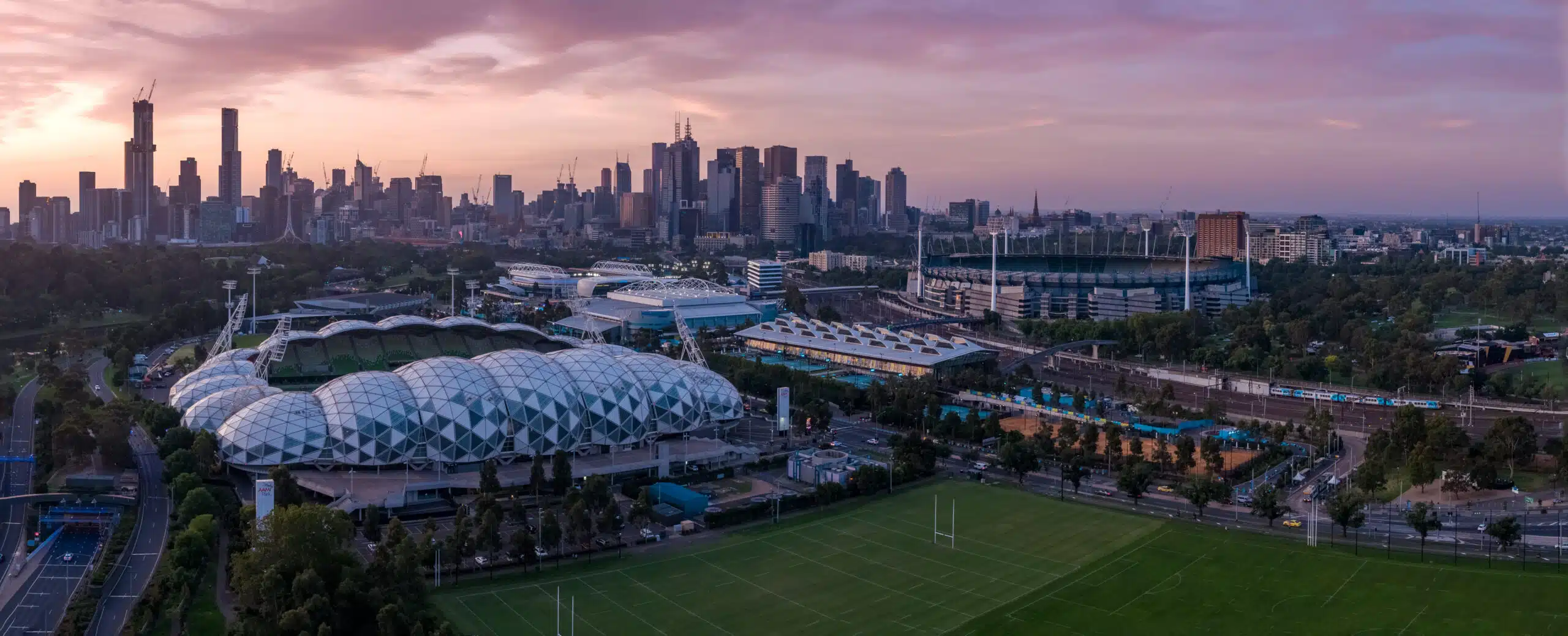
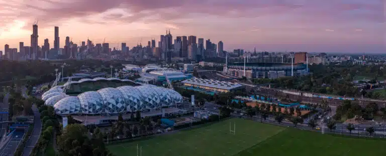
In recent years, drone technology has revolutionised the way we capture and interpret the world around us. No longer confined to aerial photography, today’s unmanned aerial vehicles (UAVs) deliver centimetre-accurate maps and 3D models that inform critical decisions in urban planning and infrastructure development.
In Melbourne, where a delicate balance between historic streetscapes and rapid modernisation poses unique challenges, drone applications in urban planning and construction have become indispensable tools for architects, engineers and city managers.
Table of Contents
Pricing packages to suit your business
Plans with inclusions for Drone Inspection, Land Surveying, 3D Laser Scanning, Drone Photography & Videography. Get custom quote for your specific requirement.
Gone are the days when planners rely solely on satellite imagery or ground-based surveys. Thanks to drones, we can generate high-resolution orthomosaics, digital terrain models and LiDAR-enhanced point clouds in a fraction of the time and cost!
From assessing the suitability of a new mixed-use precinct in Docklands, to tracking the expansion of green corridors along the Yarra River, benefits of drone mapping in urban planning include unmatched detail, rapid turnaround and safer data collection.
Urban Planning Applications
1. Land Use & Zoning with Precise Pinpoints
Successful zoning decisions hinge on understanding what’s on the ground today and what could go there tomorrow. Avian’s drone services in Melbourne with CASA-certified pilots fly predefined flight paths to capture current land use data, creating layered maps that overlay proposed developments onto existing structures, parks and transport corridors. This bird’s-eye view accelerates approval processes by providing clear evidence to the council and community stakeholders.
2. Gauging Environmental Impacts Within Minutes
Before bulldozers move in, environmental consultants must assess habitats, waterways and heritage flora. Equipping drones with multispectral sensors or high-resolution cameras allows rapid vegetation indexing and waterway health checks. This speeds up environmental impact assessments and helps safeguard Melbourne’s precious ecosystems around Merri Creek and in Albert Park.
3. Monitoring Urban Growth & Development
From office towers in the CBD to suburban infill in Brunswick East, monitoring progress can be labour-intensive and subjective. With scheduled drone surveying flights, project managers receive consistent, date-stamped imagery that reveals every stage of construction. By comparing monthly overlays, teams can spot delays, adjust timelines and communicate real-time status to investors and residents.
4. Smart Management of Public Spaces
Melbourne’s parks and plazas, like the Carlton Gardens or Federation Square, thrive on careful maintenance. Drones applications in urban planning benefit these types of areas by conducting rapid condition surveys, identifying worn pathways, damaged benches or cracked paving. Urban greening teams then prioritise interventions, ensuring community spaces remain safe, vibrant and accessible.
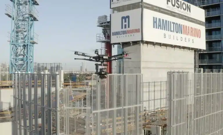
1. Construction Site Oversight & Progress Tracking
For major infrastructure programmes staying on schedule is paramount. Drone inspection flights deliver detailed aerial imagery that integrates with BIM platforms, enabling quantifiable progress reports. Construction managers no longer need to rely on ground-based spot checks; they have a continuous, holistic record of every crane, concrete pour and cladding installation.
2. Road & Bridge Inspections
Traditional inspections often involve lane closures and costly scaffolding. Drones, however, can swoop under bridges, hover above expansive road networks and capture structural details without disrupting traffic. Combined with our building inspection services, this method vastly reduces safety risks and minimises public inconvenience.
3. Utilities & Pipeline Surveys in Challenging Terrain
From the Latrobe Valley’s power lines to water mains crossing the Maribyrnong River, pipeline surveying presents safety and accessibility hurdles. Drones equipped with LiDAR sensors and thermal cameras detect subsidence, corrosion hotspots and unauthorised excavations, delivering precise geospatial data that utility companies can trust for maintenance planning.
4. Disaster Preparedness & Resilience Planning
In the event of flooding along the Yarra or bushfire threats in fringe suburbs, drones provide rapid damage assessments and flood-extent mapping. This data supports emergency responses, insurance claims and long-term resilience strategies, ensuring Melbourne’s infrastructure weathers the unexpected.
Why Melbourne’s AEC Sector Chooses Drones
Before diving into specific advantages, it’s worth underscoring the benefits of drone mapping in urban planning, from generating up-to-date land-use maps in days rather than weeks to visually communicating development scenarios to stakeholder panels.
Equally transformative is how drone mapping improves infrastructure projects, by offering precise progress tracking, early detection of alignment issues, and seamless integration of real-time data into BIM and GIS platforms, all of which drive smarter decision-making and reduce costly rework.
Outperforming Traditional Methods on Cost & Speed
Field crews once spent days erecting tripods and hiking over uneven ground. Drones complete the same work in hours, with fewer personnel and less equipment. When you compare manpower, equipment rental and data processing time, it’s clear why the overall costoften undercuts traditional surveys and delivers richer datasets.
Unrivalled Accuracy & Granularity
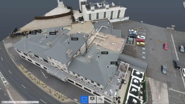
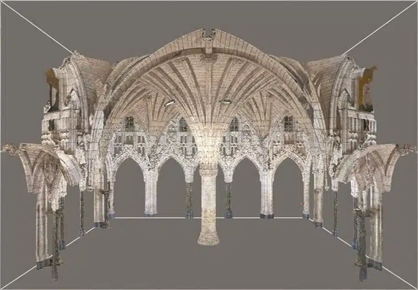
Modern UAVs paired with thorough GPS and RTK modules routinely achieve sub-10 cm accuracy. When integrated with professional 3D laser scanning services, you gain a digital twin that captures every hatch pattern on a rooftop or crack in a bridge soffit, details that fall through the cracks of lower-resolution methods.
Prioritising Safety & Reducing Site Risks
Sending workers atop towers or underpasses exposes them to height and traffic dangers. Drones eliminate the need for scaffolds or rope access in many cases, shifting risk from humans to remotely operated aircraft. Combined with our 3D Laser Scanning vs. Traditional Surveying workflows, this approach keeps teams safer while securing high-quality deliverables.
Our Melbourne Case Studies
Terrain Mapping & Contours for Urban Renewal:
In a transformative precinct redevelopment near Southbank, Avian conducted a dual drone-and-terrestrial LiDAR survey to generate detailed terrain contours. The resulting digital elevation model informed both stormwater design and podium landscaping, saving three weeks of iterative revisions.
During the Chapel Street streetscape improvement, our team executed monthly drone surveying flights. By overlaying time-lapse orthomosaics, the client demonstrated compliance with Heritage Victoria conditions and kept community groups informed—achieving consensus for smooth project delivery.
All commercial drone applications in urban planning across Melbourne must follow CASA’s Part 101 regulations and be flown by licensed remote pilots. Additionally, flights near public events, such as AFL matches at the MCG, or over critical infrastructure require council approvals. Our team handles permit applications on your behalf, liaising with relevant authorities to keep your project airborne and on schedule.
Privacy & Data Protection
High-resolution images can inadvertently capture sensitive information, like private backyards or personal vehicles. Avian adheres to best practices for data anonymisation, securing imagery storage and obtaining necessary permissions to respect privacy and maintain community trust.
Actionable Insights from the Sky
Beyond stunning visuals, one of the greatest benefits of drone mapping in urban planning lies in its ability to generate actionable intelligence.
By analysing volumetric data and change detection reports, planners can measure cut-and-fill volumes, assess traffic flow impacts on Chapel Street, or model stormwater pathways across Docklands, with a level of precision ground surveys simply can’t match.
This is also how drone mapping improves infrastructure projects: identifying subsidence early on a rail overpass or pinpointing wear patterns on road surfaces, so maintenance teams can intervene proactively rather than reactively.
Next-Generation Aerial Mapping
Integrating GIS & BIM for Holistic Insights
As Melbourne pursues its Smart City ambitions, drone-derived datasets feed directly into GIS platforms and BIM environments, creating interoperable models that support everything from traffic flow analysis to green-space management.
AI & Machine Learning: From Data Overload to Actionable Intelligence
Manual interpretation of millions of data points is a thing of the past. Machine learning algorithms can automatically classify land cover, detect structural defects and forecast material degradation, supercharging the analytical power of drone surveys.
Pioneering Smart City & Community Engagement
Imagine a virtual city model updated weekly, allowing residents and planners to visualise infrastructure upgrades or park enhancements in real time. With drone mapping at the core, Melbourne can better engage citizens, foster collaboration and ensure urban growth remains sustainable.
Taking Flight with Avian
From early feasibility studies to final as-built inspections, Avian’s drone services stand at the forefront of aerial mapping innovation. Whether you seek to understand the benefits of drone mapping in urban planning or how drone mapping improves infrastructure projects, our integrated approach delivers the clarity you need: speed, accuracy and safety.
Ready to Transform Your Next Project?
Get in touch with Avian today to discuss how our drone and aerial mapping expertise can elevate your urban planning or infrastructure venture.
Have a custom requirement ?
Get a quick estimate for your specific project requirements with listed inclusions/exclusions.