As a professional in the field of surveying, I have witnessed the rapid development of technology in the industry. One of the most significant advancements in recent years is the use of drone mounted LiDAR technologies. LiDAR (stands for light detection and ranging) is a remote sensing method that uses lasers to measure distances to the earth’s surface, creating highly accurate 3D models of terrain and objects. In this comprehensive guide, I will discuss the advantages of using LiDAR technology in surveying using drones, the drone LiDAR survey process and equipment, drone mounted LiDAR versus traditional aerial surveying using airplanes, applications of surveying with LiDAR, challenges and limitations of LiDAR surveying, and the future of LiDAR surveying.
Table of Contents
Our Project Portfolio
A few of our past projects from our years of experience of working with 100+ clients in AEC Industry carrying out 3D Laser Scanning, modelling, volumetric calculations, aerial inspections, mapping & contour surveys, aerial land surveying, photomontage and much more.
LiDAR technology has been around since the 1960s, but in the last decade has increasingly become a viable option for aerial surveying, especially on land areas with trees and vegetation. LiDAR works by emitting laser pulses and measuring the time it takes for the pulses to return to the sensor. The data collected is used to create highly accurate 3D models of the terrain and objects below. LiDAR technology has become more popular in the surveying and geospatial industry due to its ability to collect accurate data quickly and efficiently over large areas and in light to moderate vegetation.
What is an aerial survey?
An aerial survey is a method of collecting data from above. Aerial surveys can be conducted using a variety of methods, including drones, airplanes, and helicopters. Aerial surveys are used to collect high-resolution images, measurements and data including topographic data, vegetation, land mapping and environmental data. While LiDAR uses laser pulses to measure distances, photogrammetry uses overlapping photographs from different angles to calculate camera positions to measure distances.
Advantages of using LiDAR technology for aerial surveying
LiDAR technology has several advantages over traditional aerial surveying methods. One of the most significant advantages is the accuracy of the data collected. LiDAR technology can collect data with an accuracy of up to 1cmhorizontal (x,y) and 2cm vertical (z), which is significantly more accurate than traditional aerial surveying methods using conventional aircraft. LiDAR technology is also faster than traditional methods, as it can cover large areas quickly and efficiently. Additionally, LiDAR technology can penetrate moderate vegetation and other obstacles, allowing for a more complete picture of the terrain below. This is a benefit in areas with long grass or vegetation and when natural surface or accurate ground levels are required.
The drone LiDAR survey process involves several steps and can be more complex than people realise. Especially the data processing and quality control aspects of delivering quality geospatial data.
The first step is to agree to the project and data deliverables. Although LiDAR is a great technology it is not suited to many survey applications and can be prohibited by time, location, data quality and budget. Once the decision has been made to deploy drone LiDAR technology the project methodology, including mission planning and survey area must first be decided. This involves determining the right data acquisition methodology, flight path, altitude and sensor settings of both the drone and LiDAR sensor. The next step is to plan and prepare for the fieldwork and site operation. This involves careful planning and equipment preparation to ensure there are no delays, errors or hindrances once you arrive at the survey location. Often the saying holds true for technology in the field, ‘two is one and one is none’.
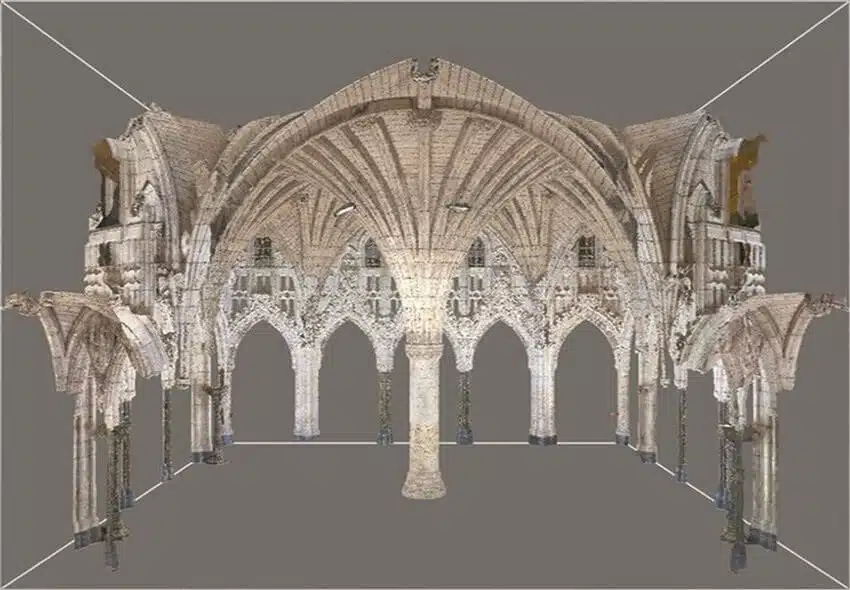
Once we are setup and ready the data collected by drone and validated with traditional survey methods is taken to the office and quality checked and processed to create a point cloud, 3D digital models and 2D CAD plans of the terrain and topography.
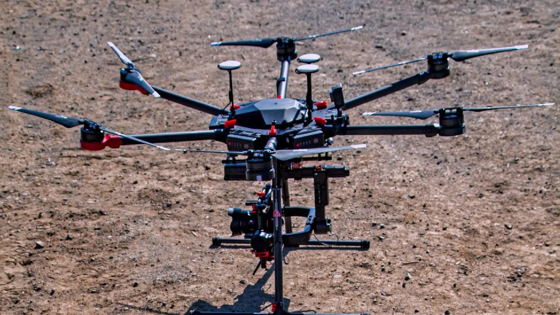
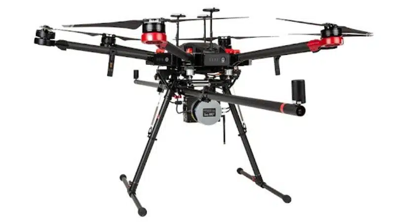
The equipment used for LiDAR surveying includes a drone equipped with a LiDAR sensor, a GPS/GNSS and RTK system, a GNSS RTK Rover for survey control and a dedicated computer for data processing. The LiDAR sensor is typically mounted on the underside of the drone, and the RTK system is used to track and record the precise location of the drone during the survey to correctly position the LiDAR sensor and camera.
Comparison of drone LiDAR vs traditional aerial surveying
Drone LiDAR and traditional aerial surveying methods both have their advantages and disadvantages. Drone LiDAR is more cost-effective and can get closer to the ground than traditional aerial surveying methods using aircraft. This results in greater accuracy due to the closer distances to the ground. However, drone LiDAR has a limited range and cannot cover large areas as quickly as using aircraft that cover larger areas, but are more expensive and less precise than drone LiDAR. The choice between drone LiDAR and aircraft mounted LiDAR aerial surveying methods depends on the specific needs and unique requirements of the project.
LiDAR aerial surveying has a wide range of applications in various industries. In the construction industry, LiDAR surveying is used to create accurate 3D models of construction sites, which can be used for planning, engineering and design. This is especially efficient in civil construction on roads, rail and commercial infrastructure projects.
In the mining industry, LiDAR surveying is used to create accurate maps of mine sites, which can be used for planning, compliance and monitoring. In the utilities industry, power lines, generation assets and transmission infrastructure can be inspected and monitored
In the environmental industry, LiDAR surveying is used to map vegetation, monitor erosion, determine water flows and track changes in land use and management.
Challenges and limitations of LiDAR aerial surveying
Despite its many advantages, LiDAR aerial surveying has several challenges and limitations. One of the most significant challenges is the cost of the equipment and data processing. LiDAR equipment can be expensive and data processing can be time-consuming and require specialised software. In recent years, LiDAR technology has decreased in cost and in some cases is easier to deploy. However, LiDAR surveying is limited by weather conditions, as rain, fog, humidity and clouds can interfere with the accuracy of the data collected.
Future of LiDAR aerial surveying
The future of LiDAR aerial surveying is bright, as new technology and advancements will continue to improve the accuracy and efficiency of the technology. One area of development is the use of artificial intelligence and machine learning algorithms to improve the accuracy and speed of data processing. Additionally, the use of smaller and more cost-effective LiDAR sensors and drones will make the technology more accessible to smaller businesses, organisations and individuals.
Conclusion
LiDAR technology has revolutionised the surveying industry, offering unparalleled accuracy and efficiency. The advantages of using LiDAR technology for surveying with drones are numerous, including faster data collection, higher accuracy, and the ability to penetrate through vegetation and other obstacles. What would take a surveyor weeks in the field, can be achieved in days with more comprehensive data obtained in a shorter time frame.
Have a question for us ?
Our team is eagerly waiting to know about your queries. Please call us at the number below during business hours and our team will help you out.